PHOTOS: Contra los terahercios en aeropuertos

Gracias por visitar el sitio de Juantxo Cruz

Material para evitar que se vean partes sensibles en los escáneres.

Gracias por visitar el sitio de Juantxo Cruz

Por Rocky Flats Gear.
17$

Gracias por visitar el sitio de Juantxo Cruz

Resultado de un escáner con sensores que captan y emiten frecuencias de terahercios.
Próximamente, en los aeropuertos de EEUU.

«A lot of other researchers thought that terahertz remote sensing was mission impossible,» said physicist Jingle Liu of Rensselaer Polytechnic Institute, lead author of the study published July 11th in Nature Photonics.

Gracias por visitar el sitio de Juantxo Cruz

PHOTOS: Caza Ching-Kuo, made in Taiwan

El nuevo caza de las Fuerzas Armadas de Taiwán.
24 millones de dólares.

Gracias por visitar el sitio de Juantxo Cruz


Ching-Kuo Indigenous Defence Fighter
(IDF).

Dimensions:Length 46ft 7.3inWidth30ft 10.78inHeight at Tail15ft 6inEngines:Turbofan Engines2 x TFE1042Thrust41.1KN maximum thrustWeapons:Integrated Avionics and Weapons Control System GunsA20mm M61A Vulcan cannonCameraPhoto-Sonics gun cameraShort-Range Air-to-Air MissilesTien Chien I (Skysword I)Medium-Range Air-to-Air MissilesTien Chien II (Skysword II )Anti-Ship MissilesHsiung Feng II Air-to-Surface MissilesMaverickOthersRocket pods
Bombs
Cluster bombs
Featured Suppliers:

Data Device Corporation – Electronic Components for the Air Force and Military Markets
ISO Group – Spare Parts Logistics for Military Aircraft

Gracias por visitar el sitio de Juantxo Cruz

F-RS-2 Fighter

Con ayuda de EEUU (General Dynamics).
Similar a un F-16, un poco más pequeño.

GRAPHICS: Ultra high density seat!

Gracias por visitar el sitio de Juantxo Cruz

Por Aviointerior.
The SkyRider.
Diseño italiano.

Gracias por visitar el sitio de Juantxo Cruz

Since 1974 Aviointeriors has supplied airline companies with customized aircraft cabin interior products. Focused mainly on passenger seat design, engineering and manufacturing, Aviointeriors also performs design, engineering and production of aircraft cabin furniture, sidewalls, galleys, lavatories. Its Railinteriors subsidiary, also supplies complete interiors for rolling stock in «high tech» composite materials.

Aviointeriors S.p.a.
Via Appia Km. 66,4
04013 Latina, ITALY

Gracias por visitar el sitio de Juantxo Cruz

Air Transport News
12 de julio

GRAPHICS: Estudios de la nube de ceniza

17 de abril de 2010, NASA

Gracias por visitar el sitio de Juantxo Cruz

False-color infrared image of Iceland’s Eyjafjallajökull volcano acquired Sat., April 17, 2010, by the Advanced Land Imager (ALI) instrument onboard NASA’s Earth Observing-1 (EO-1) spacecraft. Strong thermal emissions, shown in red, are visible at the base of the ash plume and above and to the right from earlier lava flows located at Fimmvorduhals. Image credit: NASA/JPL/EO-1 Mission/GSFC/Ashley Davies

Gracias por visitar el sitio de Juantxo Cruz

19 de abril, espectómetro
The Multi-angle Imaging SpectroRadiometer (MISR) instrument on NASA’s Terra satellite captured these different views of the ash plume from Iceland’s erupting Eyjafjallajökull volcano on April 19, 2010, which provide information on the amount and type of particles in the plume itself. Left: a true-color nadir (vertical) view; left-center: a map of retrieved aerosol optical depth, a measure of the amount of particulate matter in the atmosphere; right-center: the Angstrom exponent, which is related to average particle size; right: particle shape. Image credit: NASA/GSFC/LaRC/JPL, MISR Team

Gracias por visitar el sitio de Juantxo Cruz

A computer-analyzed map of ash plume heights, corrected to compensate for the effects of wind. Reds are highest, blue lowest. Image credit: NASA/GSFC/LaRC/JPL, MISR Team

Gracias por visitar el sitio de Juantxo Cruz

Photo-like satellite images give us a view of the world that is relatively familiar to us; the images look a lot like a digital photo. But for many scientific studies, a photo-like image doesn’t provide enough information. For example, to predict where the ash from an eruption may spread or how it might interact with clouds, scientists need a mathematical way to describe the concentration of particles in the air.

Gracias por visitar el sitio de Juantxo Cruz

Cloud-Aerosol Lidar and Infrared Pathfinder Satellite Observations (CALIPSO) satellite watches Eyjafjallajökull’s plume drift over northern Europe. Credit: NASA/Kurt Severance and Tim Marvel

GERMAN AEROSPACE CENTER
Resultados del estudio realizado con un Falcon 20E para observar el impacto de las cenizas en el aparato.
Realizado el 19 de abril, publicado el 20.

La prueba fue satisfactoria, en Alemania.
No se apreciaron daños.

Gracias por visitar el sitio de Juantxo Cruz

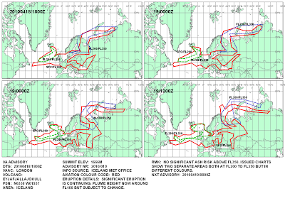
On 19 April 2010 the DLR ‘Falcon 20E’ research aircraft took off from Oberpfaffenhofen at 16:00 CEST to examine the ash cloud from the Icelandic volcano Eyafjallajoküll. The route for this measurement flight led from Oberpfaffenhofen to Leipzig, then over Hamburg and on to Bilthoven (the Netherlands) and returned via Stuttgart to Oberpfaffenhofen.

Gracias por visitar el sitio de Juantxo Cruz

Figure 1: Flight route of the DLR Falcon on 19 April 2010

Gracias por visitar el sitio de Juantxo Cruz

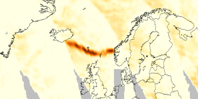
Figure 2: FLEXPART simulations of the time evolution of an aerosol tracer released from the Iceland volcano (release rate inferred from MSG observations) since 14 April 2010. Total columns (pmol/mol) on 16 April, 15 UTC (a), 17 April, 15 UTC (b), 18 April, 15 UTC, and 19 April, 17 UTC (conditions during the Falcon flight).

Gracias por visitar el sitio de Juantxo Cruz

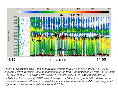
Figure 5: Quicklook from 2-μm lidar measurements from Falcon flight on April 19, 2010 showing Signal-to-Noise Ratio shortly after take-off from Oberpfaffenhofen from 14:30-14:50 UTC (16:30-16:50 LT) going north during 20 minutes (about 200-240 km flight track); red/black colors show high SNR from clouds (around 3 km) and ground (0 km); blue-green colors show layers with aerosol; white/blue colors indicate noise (no valid data); 2 layers of higher aerosol level are visible at 4 km and 5.5 km

MAPS: Mancha polémica

Gracias por visitar el sitio de Juantxo Cruz

Icelandair GROUP acaba de publicar una nueva web con información sobre el volcán.
Este es el mapa que da hoy sobre la mancha contaminante en Islandia (mini mancha).

Este son los mapas de las previsiones de la mancha de ceniza que METOFFICE ha publicado todos estos días.
La fuente es la Oficina Meteorológica de Islandia.
No se ha dado información precisa de cómo se han elaborado estos mapas.
No hemos visto fotografías detalladas de satélite (difíciles de ver por las borrascas y las nubes, pero el problema requería algo más científico que estos mapas)
No hemos visto estudios precisos sobre el impacto de las cenizas en los motores.
Tampoco hemos visto los resultados de las pruebas que las compañías hicieron en los motores.

Ayer, CIVIL AVIATION Authority del Reino Unido publicó unas nuevas líneas maestras sobre el uso del espacio aéreo.
Hoy por la tarde se esperan los primeros vuelos desde Heathrow.

Gracias por visitar el sitio de Juantxo Cruz

14 de abril

Gracias por visitar el sitio de Juantxo Cruz

16 de abril

Gracias por visitar el sitio de Juantxo Cruz

17 de abril
Caos total

Gracias por visitar el sitio de Juantxo Cruz

18 de abril

Gracias por visitar el sitio de Juantxo Cruz

19 de abril

Gracias por visitar el sitio de Juantxo Cruz

20 de abril

Gracias por visitar el sitio de Juantxo Cruz

21 de abril
Fin del problema.

Gracias por visitar el sitio de Juantxo Cruz

Morgunbladid, Islandia
Los ganaderos del sur de Islandia son los que más motivos tienen para preocuparse.
Animales bajo techo, agua potable y comida sana.
Se esperan fuertes lluvias que limpien el aire y el suelo. Esperan un cosechón. Las cenizas son un excelente abono.

Gracias por visitar el sitio de Juantxo Cruz

Neue Westfälische, Alemania
Las finanzas del sector aéreo en el suelo.
Los ejecutivos piden ayudas al gobierno.

Gracias por visitar el sitio de Juantxo Cruz

Frankfurter Allgemeine, Alemania
La nube.

Gracias por visitar el sitio de Juantxo Cruz

Daily Express, UK
Finalmente, los cielos abiertos.

Gracias por visitar el sitio de Juantxo Cruz

The Daily Telegraph, UK
¿Por qué se impuso la restricción?
Glups, Nick Clegg puede freir en cenizas esta noche a Brown.

Gracias por visitar el sitio de Juantxo Cruz

Südwest Presse, Alemania
Las líneas aéreas desafían las restricciones

Esto, ¿no era de antes de ayer?

Gracias por visitar el sitio de Juantxo Cruz

Rheinische Post, Alemania
Estudio sobre las cenizas
La ceniza: tan dura como el acero.

Sí, pero se las llevó el viento.

PRESS: Martes de ceniza

Gracias por visitar el sitio de Juantxo Cruz

Morgunbladid, Islandia

Incertidumbre y preocupación bajo la isla de las montañas.
Fuerza amenazante debajo de la tierra.
Mientras, las producción de cenizas disminuye.
No significa que vaya a parar.
Llegan a menos altura.
‘According to meteorologist Halldor Bjornsson, it is not possible to say the reduced ash fall means the eruption is winding down; but farmers are welcoming the development nevertheless. At its peak, 750 tonnes of ash were spewing out of the volcano every second. The eruption has been upgraded from small to medium in size’.
10 centímetros de cenizas en el suelo.
El problema se les cae encima.
Tres vídeos de las explosiones de ayer.
Gracias por visitar el sitio de Juantxo Cruz
Mapa turístico del sur de Islandia.

GRAPHICS: A330-200, sensores de velocidad

Gracias por visitar el sitio de Juantxo Cruz

Folha de S. Paulo
Sábado, 6 de junio

Gracias por visitar el sitio de Juantxo Cruz

Afirma Folha que Air France comunicó a sus pilotos que iba a modificar los sensores externos de la flota de Airbus, una operación rutinaria, un día después del accidente. Los técnicos han visto incoherencias en las mediciones de la velocidad y la altitud de los aviones. De nuevo vuelve la polémica de las revisiones en tierra.

Gracias por visitar el sitio de Juantxo Cruz

O Globo
Sábado, 6 de junio

!Gracias por visitar mi sitio! | Copyright © 1992- 2024 juantxo_cruz. Todos los derechos reservados.