GRAPHIC GEMS: Atlas zu Alex. v. Humboldt’s Kosmos in zweiundvierzig, 1851

Gracias por visitar el sitio de Juantxo Cruz

Atlas zu Alex. v. Humboldt’s Kosmos in zweiundvierzig
Infographic on the composition of the earth’s crust
Stuttgart, Alemania
Verlag von Krais & Hoffmann
1851
42 infografías para la historia.
No sólo un atlas. No sólo mapas.
Incluyen increíbles ilustraciones para explicar los fenómenos naturales.

Gracias por visitar el sitio de Juantxo Cruz

Ver Botanicus

MAS:
Galería en Flickr

Bibliodyssey

The rise of thematic or special purpose cartography, which focuses on mapping the distribution of single or multiple interrelated phenomena, had its origins in the advances in the natural sciences in the late eighteenth and early nineteenth centuries, particularly with the collection of vast amounts of scientific data and the search for innovative techniques of presenting this data graphically. Examples of early physical geography atlases in the Library of Congress include Alexander von Humboldt’s Atlas gographique et physique du royaume de la Nouvelle-Espagne (Paris, 1811), which records his observations during a 1799 to 1804 expedition to South and Central America; Heinrich Berghaus’s three-volume Physikalischer Atlas (Gotha, 1845 1848), the first atlas to portray the physical geography of the world; Alexander Keith Johnston’s Physical Atlas (Edinburgh, 1848), an English adaptation of the Berghaus atlas; and Traugott Broome’s Atlas zu Alex. v. Humboldt’s Kosmos [Stuttgart, 1851 1853], which was prepared to accompany Humboldt’s five-volume Kosmos, a complete physical geography of the universe.

DESIGN: Euros por Coronas, Estonia, 1 de enero de 2011

Gracias por visitar el sitio de Juantxo Cruz

Estonia entra en la zona euro.
La nueva moneda.
Adiós corona el 15 de enero.
Vídeos sobre la entrada de Estonia.

Gracias por visitar el sitio de Juantxo Cruz

Press Kit.

On 1 January 2011, the euro will become legal tender in Estonia, replacing the Estonian kroon at the irrevocably fixed exchange rate of €1 = EEK 15.6466.
The kroon will cease to be legal tender from 15 January 2011.

Interactivo: las fechas de entrada.

MAP GEMS: Familia Ottens, Joachim, Reiner y Joshua

JOACHIM OTTENS (Padre) 1663-1719
REINER AND JOSUA OTTENS (hijos)
(1698-1750 and 1704-1765)
Cartógrafos

The family business of print and map selling was founded by Joachim Ottens but the active period of map publishing was concentrated in the years between 1720 and 1750 when the brothers, Reiner and Joshua, produced enormous collections of maps, some as large as 15 volumes. These, including copies of practically all maps available at the time, were made up to order and were magnificently coloured. Besides these specially prepared collections they also issued single-volume atlases with varying contents as well as pocket atlases.

Cartografía en venta.

Gracias por visitar el sitio de Juantxo Cruz

Publisher: de L’ISLE, G. / OTTENS, R. / I.
Title: Hemisphere meridional pour voir plus distinctement les terres australes. . .
Published in: Amsterdam, 1740

Size: 17.6 x 17.9 inches.
44.7 x 45.4 cm.

Gracias por visitar el sitio de Juantxo Cruz

With the imprint of the Ottens family – rare. An Antarctic map including a recounting of the discovery of an island south of the Cape of Good Hope which was named Cap de la Circoncision in 1739. A small inset map of the discovered island appears in the lower right.
This circular map show the world in an unusual way: using the Poles as the center point of hemispheres that extend to the Equator.
With a text panel in upper left corner : Nouvelles découvertes de 1739 au sud du cap de bonne Esperance par les ordre de M. de la compagnie des Indes. Dressee sur les memoires et sur la carte originale de M. Lozier Bouvet cahrge de cette expédition. Same text in Dutch in upper right corner.
Joachim Ottens (1663 – 1719) and his sons Renier and Joshua were prominent Dutch booksellers and map publishers from about 1680 to 1790. Joachim, the founder of the firm, was initially employed as a copperplate engraver by Frederick de Wit. In 1711 Joachim founded his own firm. Though Joachim died only a few years later, his sons Renier and Joshua took over the firm and presided over its most prolific period.

Gracias por visitar el sitio de Juantxo Cruz

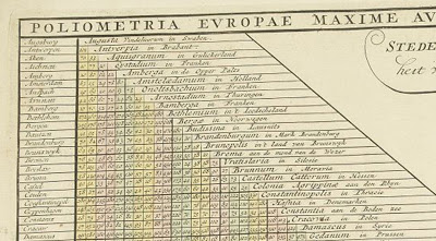
European Distance Chart, Reiner and Josua Ottens, c.1750
OLIOMETRIA EUROPAE MAXIME AUTEM GERMANIAE AC FINITIMORUM LOCURUM EX OFFICINA R. & J. OTTS AMST. An interesting table listing many European towns and cities plus Bethlehem.
Gracias por visitar el sitio de Juantxo Cruz

Publisher: OTTENS, R. / I.
Title: Poliometria Europae Maxime Autem Germaniae ac Finitimorum Locorum. . .
Published in: Amsterdam, 1720
48.6 x 55.3 cm.

Gracias por visitar el sitio de Juantxo Cruz

This unusual thematic chart shows the traveling distances from various European cities in a style that is still used in charts today.

Gracias por visitar el sitio de Juantxo Cruz

Reiner & Josua Ottens: Carte Quirepresente Toutes Les Pieces Qui Sont Comprises Dans L’Architecture Militaire, ou L’Arte Des Fortifications . . .

Description: Scarce map showing approximately 83 smaller illustrations on all aspects of the military sciences, including methods for the construction of fortresses; artillery; sieges of cities; battles; army units, attacks from seaside etc., but Caspar Specht. The text of the legend in Dutch, text in the illustrations in French. Gorgeous old color example.

Title: Carte Quirepresente Toutes Les Pieces Qui Sont Comprises Dans L’Architecture Militaire, ou L’Arte Des Fortifications . . .
Map Maker: Reiner & Josua Ottens
Place / Date: Amsterdam / 1720

Gracias por visitar el sitio de Juantxo Cruz

Reiner & Josua Ottens: [Wall Map of Spain & Portugal] Novissima et Accuratissima Tabula Qua Gallaeciae et Legionis Regna, Asturiarum … Regnorum Arragoniae et Navarra, Principatus Cataloniae . . .

Title: [Wall Map of Spain & Portugal] Novissima et Accuratissima Tabula Qua Gallaeciae et Legionis Regna, Asturiarum … Regnorum Arragoniae et Navarra, Principatus Cataloniae . . .

Map Maker: Reiner & Josua Ottens
Place / Date: Amsterdam / 1740

Description:

Gorgeous full color example of Luggert van Anse’s 4 sheet map of Spain, Portugal and the Balaeric Islands, joined flawlessly and presented here as a wall map.

Includes a large cartouche with explanations of the political divisions of Spain and Portugal in French and Dutch, headed by coat of arms and 6 compass roses. An uncommon wall map of Spain and Portugal. Luggert van Anse was engraver for Allard, Visscher and van Keulen. This edition was published by Ottens, with additions and corrections. A spectacular example.
Price: $4,800.00

Gracias por visitar el sitio de Juantxo Cruz

Johannes De Ram / Reiner & Josua Ottens: Regni Angliae Nova Tabula, Exhibens Principatum Walliae, & aliarum Provincia rum Civitatum, Oppidorum, una cum itineribus ab uno in aliam Civitatem

Title: Regni Angliae Nova Tabula, Exhibens Principatum Walliae, & aliarum Provincia rum Civitatum, Oppidorum, una cum itineribus ab uno in aliam Civitatem

Map Maker: Johannes De Ram / Reiner & Josua Ottens
Place / Date: Amsterdam / 1725
Size: 23 x 19.5 inches
Price: $795.00

Description:
Third state of De Ram’s rare map of England, updated and corrected by Reiner & Josua Ottens.

Includes a massive Alphabetical Table of the Cities and Market-Townes on the great roads in England Y Wales, Their Latitude and Longitude and in what County they are Lying . . . Ornate cartouche and rich full color.

Gracias por visitar el sitio de Juantxo Cruz

Totius Neobelgii nova et accuratissima Tabula
Allard, Hugo (1625 – 1691)/Ottens, Reiner (1698 – 1750) and Ottens, Joshua (1704-1765)
Librería: W. Graham Arader III gallery (New York, NY, U.S.A.)


Descripción:

A MAP OF NEW ENGLAND CONTAINING THE FAMOUS «RESTITUTIO» VIEW Copper-plate engraving with original hand color: plate size 181/2″ x 213/4″ Reference: Philip D. Burden, The Mapping of North America: A List of Printed Maps 1511-1670 (Rickmansworth, 1996), 476-477. This map is one of five that closely follows the Visscher Novii Belgii. It is a magnificent version of Hugo Allard’s edition published by the Ottens brothers, after their purchase of Allard’s plate in 1708, and shows the famous «Restitutio» view of New York. In 1664, the English successfully captured New Amsterdam and renamed it New York. The Dutch were entirely unable to rival the English, but for one brief episode between 1673 and 1674 when they recaptured the city and renamed it New Amsterdam. It was then that this updated version of Visscher’s map was first engraved replacing the inset view of New York with what became dubbed the «Restituto» view. The inset celebrated the ‘restoration’ of New Amsterdam to Holland, in August 1673, by the fleet under the command of Cornelius Evertsen. The figure on the pedestal is holding a laurel of victory, while the updated glimpse at the southern tip of Manhattan shows a city that has grown significantly, and is a triumphant indication of Dutch pride in its recapture. Unlike the Visscher view, here the town is depicted from the east. On the right-hand side of the view is part of the wall that became Wall Street, with its guardhouse and gate. To its right are new settlements that were just beginning to crop up north of the wall. This view actually shows the Dutch capture of the town in progress, with soldiers marching along the quay and a cannon firing from the fort. Despite the fact that the city was returned to the British under the Treaty of Breda the following year, this map with the «Restitutio» view continued to be published for almost a century by Dutch mapmakers, perhaps for reasons of nostalgic national pride. By this time, Dutch overseas power was waning, particularly in America. This view, with its grandiose presentation of momentary triumph, played to the need for some affirmation of Dutch colonial power even in the face of overwhelming evidence to its demise

Gracias por visitar el sitio de Juantxo Cruz

Schenk Ottens 1700 (1735) – India

MAKER Schenk/Ottens
TITLE Carte des Côtes de Malabar et de Coromandel
PLACE ISSUED Amsterdam
FIRST EDITION 1700
THIS EDITION 1735
SIZE (hxw cms) 44.1 x 57.2
AREA SHOWN India
TECHNIQUE Copper engraving
PAGE NUMBER
SIGNATURE
VERSO blank
COLOURING or.col.
CONDITION The overall quality of this antique map is excellent
DESCRIPTION Reiner and Joshua Ottens’ re-issue of Schenk’s large map of India. Magnificent original colour.

JOACHIM OTTENS
1663-1719
Joachim Ottens and his sons Renier (d.1750) and Joshua (d.1765), were prominent Dutch booksellers and map publishers from about 1680 to 1790. Joachim was initially employed as a copperplate engraver by Frederick de Wit (1630-1706), but founded his own business in 1711. Although he died only a few years later, his sons Renier and Joshua took over the firm and presided over its most prolific period. The Ottens family’s most notable contribution to cartography was its enormous made-to-order multi-volume atlases such as the Atlas Major.

Gracias por visitar el sitio de Juantxo Cruz

Reiner Ottens. Atlas maior cvm generales omnivm totius orbis regnorvm . . .Amsterdam 1729. Page 2 – Page 3 Hand-colored engraving

REINER OTTENS
(son) 1698-1750

JOSHUA OTTENS
(son) 1704-1765

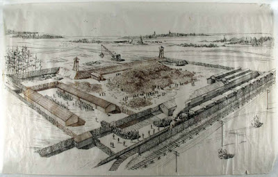
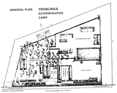
ILLUS: Treblinka, Samuel Willenber

Campo de exterminio de Treblinka
Polonia
Solución final.
Desde julio de 1942
870.000 asesinados.
Aktion 1005: la campaña nazi para destruir las evidencias y cerrar el campo (desde marzo hasta julio de 1943.
Destrucción total y se reconvirtió en una granja.
Comandantes Franz Stangl y Kurt Franz, sentenciados de por vida.

Samuel Willenber fue un superviviente del campo.

Gracias por visitar el sitio de Juantxo Cruz

Ilustración del campo de concentración.
Samuel Willenberg, 1923

Gracias por visitar el sitio de Juantxo Cruz

Otra recreación de Samuel Willenberg

Samuel Willenberg was born in Czestochowa in 1923. His father was a painter and teacher in the local Jewish middle school and his mother was Russian. The family moved to Warsaw shortly before the outbreak of World War II. In 1939 Willenberg volunteered for the Polish army and was wounded in fighting against the Soviets in the east of the country. In 1940 he moved to Opatow where he continued to teach privately. In 1942, in spite of possessing false documents identifying him as an Aryan, he was arrested and sent to the concentration camp at Treblinka along with the entire Jewish population of Opatow. Upon arriving at the camp, he claimed to be a brick mason and thus succeeded in avoiding death in a gas chamber. He participated in a prisoners’ revolt in August of 1943, during which he was able to escape and get back to Warsaw. With the outbreak of the Warsaw Uprising, he joined up with a unit of the Home Army (AK), and in September transferred to the PAL fighting organization. Following the fall of the uprising he received a series of medals: the Virtuti Militari 5th class, two Hearts of Valor, the Silver Cross of Merit and the PAL golden fighting badge. In 1950 he left Poland for Israel with his entire family. There, he worked for many years as the Chief Inspector of Measurements in the Ministry of Land Development. Upon retiring, he enrolled in the People’s University, where he studied painting, sculpture and art history. In 1994 he was once again granted Polish citizenship.

STATS: Sport+Markt, estrategia deportiva

Gracias por visitar el sitio de Juantxo Cruz

Sport+Markt
Análisis, consultoría, investigación
Deporte internacional
Bases de datos.
Proyectos en más de 120 países de todos los continentes
Constitución en 1986 en Colonia, Alemania
Sociedad Anónima desde el año 2000
Sedes en seis países
13 oficinas, con más de 500 empleados
Proyectos en más de 120 países de todos los continentes
Una de las empresas de mayor crecimiento en el sector
Estándar comercial reconocido por el mercado así como líder en innovación y servicio
Independiente y neutral
Organización de congresos propios dentro del sector (p. ej. International Football Summit)

Gracias por visitar el sitio de Juantxo Cruz

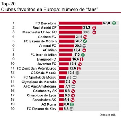
Clubes favoritos.

«Centros de Evaluación de Medios» en Colonia, Barcelona y Singapur para el análisis y el control mundial de formatos y contenidos de televisión, Internet, telefonía móvil, radio, prensa, etc

«Hacer posible el éxito de nuestros clientes en el negocio del deporte y del patrocinio internacional es nuestra misión desde hace más de 20 años y es, al mimo tiempo, el estímulo diario para que los que conformamos el equipo de SPORT+MARKT demos lo mejor de nosotros».

Hartmut Zastrow
Director Ejecutivo / SPORT+MARKT AG

Gracias por visitar el sitio de Juantxo Cruz

Estudio sobre las camisetas de fútbol
Leonardo Giammarioli
International PR Manager
Leonardo.Giammarioli@sportundmarkt.com
+49 (0) 221 – 430 73 177

SPORT+MARKT SL Barcelona
Ronda General Mitre, 126 Ãtico 1
08021 Barcelona
España

Tel.: +34 – 93 253 18 33
Fax: +34 – 93 212 41 45

info.spain@sportundmarkt.com

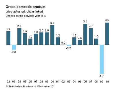
STATS: Statistisches Bundesamt Deutschland

Statistisches Bundesamt Deutschland
Federal Statistical Office, Alemania.
DESTATIS
2.700 empleados
Wiesbaden, Bonn, I-Punkt Berlin.

Gracias por visitar el sitio de Juantxo Cruz

Organigrama, estructura.
La división de gráficos y diseño depende de ‘Estrategia, planificación, relaciones internacionales, documentación y comunicación’.

Gracias por visitar el sitio de Juantxo Cruz

Los objetivos.

Gracias por visitar el sitio de Juantxo Cruz

Galería de aplicaciones interactivas.

Statistics on the internet:
user-friendly, interactive, free of charge
The number of five million page views per month confirms that the internet portal
www.destatis.de of the Federal Statistical Office has become the main source of statistical information. By extending the range of online publications and interactive applications in 2009, user access was improved. As more and more theme pages and press releases are linked with the database GENESIS-Online and with the range of international data, users find more quickly what they are looking for. The number of accesses to GENESISOnline in 2009 (about one million) was twice that of 2008: Free tables, a new navigation and a WebService for registered customers had a positive impact on demand.

Gracias por visitar el sitio de Juantxo Cruz

A new and innovative feature within the prices area is the price kaleidoscope, which is an interactive graphical application. The price development and the weighting of product groups in the consumer price index are visualised, so that the main origins of price increases or decreases are illustrated.

Price Kaleidoscope
The inflation rate in January 2010 was 0.8%. The rate of price increase does not only depend on how the prices change. Another important factor is the weights with which the price trends of the individual types of goods are included in the overall index.

The size of each section represents the weight. The colour shows how the prices
within that category of goods have changed.
Personal inflation calculator
© Statistisches Bundesamt, Wiesbaden / Michael Balzer, Universität Konstanz 2009
table vIewS In GeneSIS-OnlIne per year
159,016

Gracias por visitar el sitio de Juantxo Cruz

The STATmagazin, which is the Federal Statistical Office’s web magazine, has become
established as an element of the Office’s data supply. Short texts and charts that
are easy to understand, it provides information that is well-based in terms of statistics and deals with issues which are in the focus of public discussion. The trend in the number of free downloads from the publication service is positive: More than 100,000 free publications were downloaded every month in 2009 – with topics focusing most frequently on demographic change as well as producer and consumer prices.

Gracias por visitar el sitio de Juantxo Cruz

Since May 2009, the Federal Statistical Office, together with the statistical offices of the Länder, has offered a new interactive regional atlas with over 80 indicators at www.destatis.de/onlineatlas. The visualisation of the statistics is based on data of all rural districts and towns not attached to an administrative district in Germany.
Regional differences – for example with regard to economic power, internal migration or employment – can be seen at a glance.

!Gracias por visitar mi sitio! | Copyright © 1992- 2025 juantxo_cruz. Todos los derechos reservados.