GRAPHIC GEMS: Atlas zu Alex. v. Humboldt’s Kosmos in zweiundvierzig, 1851

Gracias por visitar el sitio de Juantxo Cruz

Atlas zu Alex. v. Humboldt’s Kosmos in zweiundvierzig
Infographic on the composition of the earth’s crust
Stuttgart, Alemania
Verlag von Krais & Hoffmann
1851
42 infografías para la historia.
No sólo un atlas. No sólo mapas.
Incluyen increíbles ilustraciones para explicar los fenómenos naturales.

Gracias por visitar el sitio de Juantxo Cruz

Ver Botanicus

MAS:
Galería en Flickr

Bibliodyssey

The rise of thematic or special purpose cartography, which focuses on mapping the distribution of single or multiple interrelated phenomena, had its origins in the advances in the natural sciences in the late eighteenth and early nineteenth centuries, particularly with the collection of vast amounts of scientific data and the search for innovative techniques of presenting this data graphically. Examples of early physical geography atlases in the Library of Congress include Alexander von Humboldt’s Atlas gographique et physique du royaume de la Nouvelle-Espagne (Paris, 1811), which records his observations during a 1799 to 1804 expedition to South and Central America; Heinrich Berghaus’s three-volume Physikalischer Atlas (Gotha, 1845 1848), the first atlas to portray the physical geography of the world; Alexander Keith Johnston’s Physical Atlas (Edinburgh, 1848), an English adaptation of the Berghaus atlas; and Traugott Broome’s Atlas zu Alex. v. Humboldt’s Kosmos [Stuttgart, 1851 1853], which was prepared to accompany Humboldt’s five-volume Kosmos, a complete physical geography of the universe.

MAP GEMS: Familia Ottens, Joachim, Reiner y Joshua

JOACHIM OTTENS (Padre) 1663-1719
REINER AND JOSUA OTTENS (hijos)
(1698-1750 and 1704-1765)
Cartógrafos

The family business of print and map selling was founded by Joachim Ottens but the active period of map publishing was concentrated in the years between 1720 and 1750 when the brothers, Reiner and Joshua, produced enormous collections of maps, some as large as 15 volumes. These, including copies of practically all maps available at the time, were made up to order and were magnificently coloured. Besides these specially prepared collections they also issued single-volume atlases with varying contents as well as pocket atlases.

Cartografía en venta.

Gracias por visitar el sitio de Juantxo Cruz

Publisher: de L’ISLE, G. / OTTENS, R. / I.
Title: Hemisphere meridional pour voir plus distinctement les terres australes. . .
Published in: Amsterdam, 1740

Size: 17.6 x 17.9 inches.
44.7 x 45.4 cm.

Gracias por visitar el sitio de Juantxo Cruz

With the imprint of the Ottens family – rare. An Antarctic map including a recounting of the discovery of an island south of the Cape of Good Hope which was named Cap de la Circoncision in 1739. A small inset map of the discovered island appears in the lower right.
This circular map show the world in an unusual way: using the Poles as the center point of hemispheres that extend to the Equator.
With a text panel in upper left corner : Nouvelles découvertes de 1739 au sud du cap de bonne Esperance par les ordre de M. de la compagnie des Indes. Dressee sur les memoires et sur la carte originale de M. Lozier Bouvet cahrge de cette expédition. Same text in Dutch in upper right corner.
Joachim Ottens (1663 – 1719) and his sons Renier and Joshua were prominent Dutch booksellers and map publishers from about 1680 to 1790. Joachim, the founder of the firm, was initially employed as a copperplate engraver by Frederick de Wit. In 1711 Joachim founded his own firm. Though Joachim died only a few years later, his sons Renier and Joshua took over the firm and presided over its most prolific period.

Gracias por visitar el sitio de Juantxo Cruz

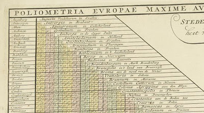
European Distance Chart, Reiner and Josua Ottens, c.1750
OLIOMETRIA EUROPAE MAXIME AUTEM GERMANIAE AC FINITIMORUM LOCURUM EX OFFICINA R. & J. OTTS AMST. An interesting table listing many European towns and cities plus Bethlehem.
Gracias por visitar el sitio de Juantxo Cruz

Publisher: OTTENS, R. / I.
Title: Poliometria Europae Maxime Autem Germaniae ac Finitimorum Locorum. . .
Published in: Amsterdam, 1720
48.6 x 55.3 cm.

Gracias por visitar el sitio de Juantxo Cruz

This unusual thematic chart shows the traveling distances from various European cities in a style that is still used in charts today.

Gracias por visitar el sitio de Juantxo Cruz

Reiner & Josua Ottens: Carte Quirepresente Toutes Les Pieces Qui Sont Comprises Dans L’Architecture Militaire, ou L’Arte Des Fortifications . . .

Description: Scarce map showing approximately 83 smaller illustrations on all aspects of the military sciences, including methods for the construction of fortresses; artillery; sieges of cities; battles; army units, attacks from seaside etc., but Caspar Specht. The text of the legend in Dutch, text in the illustrations in French. Gorgeous old color example.

Title: Carte Quirepresente Toutes Les Pieces Qui Sont Comprises Dans L’Architecture Militaire, ou L’Arte Des Fortifications . . .
Map Maker: Reiner & Josua Ottens
Place / Date: Amsterdam / 1720

Gracias por visitar el sitio de Juantxo Cruz

Reiner & Josua Ottens: [Wall Map of Spain & Portugal] Novissima et Accuratissima Tabula Qua Gallaeciae et Legionis Regna, Asturiarum … Regnorum Arragoniae et Navarra, Principatus Cataloniae . . .

Title: [Wall Map of Spain & Portugal] Novissima et Accuratissima Tabula Qua Gallaeciae et Legionis Regna, Asturiarum … Regnorum Arragoniae et Navarra, Principatus Cataloniae . . .

Map Maker: Reiner & Josua Ottens
Place / Date: Amsterdam / 1740

Description:

Gorgeous full color example of Luggert van Anse’s 4 sheet map of Spain, Portugal and the Balaeric Islands, joined flawlessly and presented here as a wall map.

Includes a large cartouche with explanations of the political divisions of Spain and Portugal in French and Dutch, headed by coat of arms and 6 compass roses. An uncommon wall map of Spain and Portugal. Luggert van Anse was engraver for Allard, Visscher and van Keulen. This edition was published by Ottens, with additions and corrections. A spectacular example.
Price: $4,800.00

Gracias por visitar el sitio de Juantxo Cruz

Johannes De Ram / Reiner & Josua Ottens: Regni Angliae Nova Tabula, Exhibens Principatum Walliae, & aliarum Provincia rum Civitatum, Oppidorum, una cum itineribus ab uno in aliam Civitatem

Title: Regni Angliae Nova Tabula, Exhibens Principatum Walliae, & aliarum Provincia rum Civitatum, Oppidorum, una cum itineribus ab uno in aliam Civitatem

Map Maker: Johannes De Ram / Reiner & Josua Ottens
Place / Date: Amsterdam / 1725
Size: 23 x 19.5 inches
Price: $795.00

Description:
Third state of De Ram’s rare map of England, updated and corrected by Reiner & Josua Ottens.

Includes a massive Alphabetical Table of the Cities and Market-Townes on the great roads in England Y Wales, Their Latitude and Longitude and in what County they are Lying . . . Ornate cartouche and rich full color.

Gracias por visitar el sitio de Juantxo Cruz

Totius Neobelgii nova et accuratissima Tabula
Allard, Hugo (1625 – 1691)/Ottens, Reiner (1698 – 1750) and Ottens, Joshua (1704-1765)
Librería: W. Graham Arader III gallery (New York, NY, U.S.A.)


Descripción:

A MAP OF NEW ENGLAND CONTAINING THE FAMOUS «RESTITUTIO» VIEW Copper-plate engraving with original hand color: plate size 181/2″ x 213/4″ Reference: Philip D. Burden, The Mapping of North America: A List of Printed Maps 1511-1670 (Rickmansworth, 1996), 476-477. This map is one of five that closely follows the Visscher Novii Belgii. It is a magnificent version of Hugo Allard’s edition published by the Ottens brothers, after their purchase of Allard’s plate in 1708, and shows the famous «Restitutio» view of New York. In 1664, the English successfully captured New Amsterdam and renamed it New York. The Dutch were entirely unable to rival the English, but for one brief episode between 1673 and 1674 when they recaptured the city and renamed it New Amsterdam. It was then that this updated version of Visscher’s map was first engraved replacing the inset view of New York with what became dubbed the «Restituto» view. The inset celebrated the ‘restoration’ of New Amsterdam to Holland, in August 1673, by the fleet under the command of Cornelius Evertsen. The figure on the pedestal is holding a laurel of victory, while the updated glimpse at the southern tip of Manhattan shows a city that has grown significantly, and is a triumphant indication of Dutch pride in its recapture. Unlike the Visscher view, here the town is depicted from the east. On the right-hand side of the view is part of the wall that became Wall Street, with its guardhouse and gate. To its right are new settlements that were just beginning to crop up north of the wall. This view actually shows the Dutch capture of the town in progress, with soldiers marching along the quay and a cannon firing from the fort. Despite the fact that the city was returned to the British under the Treaty of Breda the following year, this map with the «Restitutio» view continued to be published for almost a century by Dutch mapmakers, perhaps for reasons of nostalgic national pride. By this time, Dutch overseas power was waning, particularly in America. This view, with its grandiose presentation of momentary triumph, played to the need for some affirmation of Dutch colonial power even in the face of overwhelming evidence to its demise

Gracias por visitar el sitio de Juantxo Cruz

Schenk Ottens 1700 (1735) – India

MAKER Schenk/Ottens
TITLE Carte des Côtes de Malabar et de Coromandel
PLACE ISSUED Amsterdam
FIRST EDITION 1700
THIS EDITION 1735
SIZE (hxw cms) 44.1 x 57.2
AREA SHOWN India
TECHNIQUE Copper engraving
PAGE NUMBER
SIGNATURE
VERSO blank
COLOURING or.col.
CONDITION The overall quality of this antique map is excellent
DESCRIPTION Reiner and Joshua Ottens’ re-issue of Schenk’s large map of India. Magnificent original colour.

JOACHIM OTTENS
1663-1719
Joachim Ottens and his sons Renier (d.1750) and Joshua (d.1765), were prominent Dutch booksellers and map publishers from about 1680 to 1790. Joachim was initially employed as a copperplate engraver by Frederick de Wit (1630-1706), but founded his own business in 1711. Although he died only a few years later, his sons Renier and Joshua took over the firm and presided over its most prolific period. The Ottens family’s most notable contribution to cartography was its enormous made-to-order multi-volume atlases such as the Atlas Major.

Gracias por visitar el sitio de Juantxo Cruz

Reiner Ottens. Atlas maior cvm generales omnivm totius orbis regnorvm . . .Amsterdam 1729. Page 2 – Page 3 Hand-colored engraving

REINER OTTENS
(son) 1698-1750

JOSHUA OTTENS
(son) 1704-1765

BOOKS: Atlas of Science, The MIT Press

Gracias por visitar el sitio de Juantxo Cruz

Atlas of Science, Visualizing What We Know
Hardcover: 288 pages
Publisher: The MIT Press (October 31, 2010)
Language: English
ISBN-10: 0262014459
ISBN-13: 978-0262014458

Gracias por visitar el sitio de Juantxo Cruz

Product Dimensions: 13.2 x 11.2 x 1 inches
October 2010
13 x 11, 288 pp., 500 color illus.
$29.95/£22.95 (CLOTH)

Gracias por visitar el sitio de Juantxo Cruz

ISBN-10:
0-262-01445-9
ISBN-13:
978-0-262-01445-8

Gracias por visitar el sitio de Juantxo Cruz

Product Description
Cartographic maps have guided our explorations for centuries, allowing us to navigate the world. Science maps have the potential to guide our search for knowledge in the same way, helping us navigate, understand, and communicate the dynamic and changing structure of science and technology. Allowing us to visualize scientific results, science maps help us make sense of the avalanche of data generated by scientific research today.

Gracias por visitar el sitio de Juantxo Cruz

Atlas of Science, features more than thirty full-page science maps, fifty data charts, a timeline of science-mapping milestones, and 500 color images; it serves as a sumptuous visual index to the evolution of modern science and as an introduction to «the science of science»—charting the trajectory from scientific concept to published results.

Gracias por visitar el sitio de Juantxo Cruz

Atlas of Science, based on the popular exhibit «Places & Spaces: Mapping Science,» describes and displays successful mapping techniques. The heart of the book is a visual feast: Claudius Ptolemy’s Cosmographia World Map from 1482; a guide to a PhD thesis that resembles a subway map; «the structure of science» as revealed in a map of citation relationships in papers published in 2002; a periodic table; a history flow visualization of the Wikipedia article on abortion; a globe showing the worldwide distribution of patents; a forecast of earthquake risk; hands-on science maps for kids; and many more.

Gracias por visitar el sitio de Juantxo Cruz

Each entry includes the story behind the map and biographies of its makers.

Gracias por visitar el sitio de Juantxo Cruz

Not even the most brilliant minds can keep up with today’s deluge of scientific results. Science maps show us the landscape of what we know.

The MIT Press
Cambridge, Massachusetts
London, England
http://mitpress.mit.edu

IMAGENES.

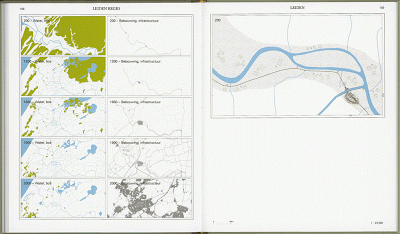
BOOKS: 010, Joost Grootens, Amsterdam

Gracias por visitar el sitio de Juantxo Cruz

Joost Grootens estudió diseño arquitectónico en la Academia Gerrit Rietveld de Amsterdam (1990-1995). Luego fundó su propio estudio, especializado en libros de arquitectura, espacios urbanos y ambiente interactivo.

Gracias por visitar el sitio de Juantxo Cruz

Uno de sus clientes es 010 Publishers Rotterdam, editora con más de 25 años en la palestra.
600 libros sobre diseño y arquitectura.
Fundado por Hans Oldewarris and Peter de Winter.

Gracias por visitar el sitio de Juantxo Cruz

Vinex Atlas
Jelte Boeijenga, Jeroen Mensink
Diseño de Joost Grootens
60 euros

Gracias por visitar el sitio de Juantxo Cruz

Medalla de oro, diseño libros, 2009 Best Dutch Book Design

Gracias por visitar el sitio de Juantxo Cruz

Cartografía de un programa de construcción de viviendas.
‘An outstanding example of successful information-based graphics. The detailed information is clearly structured, precisely collated and in its design concept shows sure instinct right down to the last detail. Excellent design of complex contents which makes the reader eager to find out more’.
Goldmedaille ‘Schönste Bücher aus aller Welt’

Gracias por visitar el sitio de Juantxo Cruz

The Metropolitan World Atlas
Arjen van Susteren
Diseño de Joost Grootens
25 euros

Gracias por visitar el sitio de Juantxo Cruz

Gracias por visitar el sitio de Juantxo Cruz

Medalla de oro, ’Best Book Design from all over the World’ 2006.

Gracias por visitar el sitio de Juantxo Cruz

Limes Atlas
Jos Bazelmans, Ton Bloemers, otros.
Diseño de Joost Grootens
45 euros

Gracias por visitar el sitio de Juantxo Cruz

Gracias por visitar el sitio de Juantxo Cruz

Best Dutch Book Design 2005

Gracias por visitar el sitio de Juantxo Cruz

The Big Kan Atlas
Wies Sanders
100 mapas sobre la red urbana Arnhem-Nijmegen.
92 páginas.
Diseño de Joost Grootens
2003.
Out of print.

MAPS: Michelín, 100 años

Gracias por visitar el sitio de Juantxo Cruz

Gracias por visitar el sitio de Juantxo Cruz

Gracias por visitar el sitio de Juantxo Cruz

La guía Michelin francesa celebra su centenario. El próximo día 5 de marzo saldrá a la venta la edición de 2009, con una portada escogida entre las 100 encargadas a artistas y estudiantes.

Michelin (Manufacture Française des Pneumatiques Michelin) también ha creado una web especial para conmemorar la ocasión.

Los mapas de Michelin son piezas clásicas de la cartografía mundial. Sobre estas líneas algunos mapas de entre 1911 y 1920.

Además de mapas y atlas, la compañía representada por ’Bibendum’ (1910) ofrece la renombrada línea de guías de viaje ’Green Travel Guides.

ARTS: La pira de los ‘hedge funds’

Gracias por visitar el sitio de Juantxo Cruz

Gracias por visitar el sitio de Juantxo Cruz

Gracias por visitar el sitio de Juantxo Cruz

Obra del artista satírico Adam Dant (Cambridge, 1967) por encargo de Spears para representar la actual gélida coyuntura económica: ‘The Triumph of Debt’ (la primera imagen). Londres en llamas, el hechizo de RAB Capital, TCI, Toscafund, Citadle y Atticus ha sido robado. Inspirada en ‘El Triunfo de la Muerte’ de Brueghel, la crisis inmortalizada por el arte. ¿Acabará alguno de estos fondos de inversión comprando la obra en la que se representa su quema en la hoguera? ¡Para volverse locos!

Impertinente creación la de Dant. Entre sus joyas, un diagrama del alma, varios altas del arte y sátiras sobre los negocios. Una visión apocalíptica de la urbe y sus bestias.

http://www.adambaumgoldgallery.com/dant/newwork.htm
http://www.spearswms.com/spears-world/shot-before-dawn/2146/adam-dant.thtml
http://www.artnet.com/artist/424152254/adam-dant.html

Atlas visual de la Guerra de Afganistán (2002)

Este Atlas visual es el documento gráfico más completo del primer gran conflicto bélico del siglo XXI. Lo ha realizado un amplio equipo de especialistas y profesionales del diario EL MUNDO. Aparecen ilustraciones con los detalles de los atentados contra las Torres gemelas y el Pentágono, una maqueta de la fortaleza de Bin Laden, miltiples imagenes, ilustraciones y calicaturas, incluso un gráfico que muestra el curso que siguieron los aviones antes de colisionar contra las torres.

11-9-01. Atlas de la guerra

Director del proyecto: Juancho Cruz
Coordinador: Daniel Izeddin Aguirre
Diseño y maquetación: Daniel Amade Castro
Edición de textos: Javier Caballero
Edición de gráficos: Marta Muela
Diseño de portada: Daniel Amade Castro
Departamento de Infografía e Ilustración: Juancho Cruz, Modesto J. Carrasco, Rafael Estrada, Chema Matía, Emilio Amade Castro, Isabel González, Daniel Izeddin, Beatriz Santacruz Suárez, Maite Vaquero, Rodrigo Silva, Mariano Zafra, Ulises Culebro y Ricardo Martínez.
Colaboradores de Infografía e Ilustración: Ricardo y Nacho, Gallego y Rey, Enrique Muñoz, Ana Paula Martínez, Daniel Amade Castro, Álvaro Undabarrena, Ajubel, Sean Mackoui, Julio Cebrián, Elena Castán, Marta Muela, Paco Díaz, Javier Caballero, Chiqui Esteban, Luis S. Parejo, LEM y Fernando Díaz.
Colaboradores durante la crisis de Afganistán: Gracia Iglesias, Marta Cabrera, Cote Villar, Pedro Simón, Daniel Montero, Luis Ángel Sanz, Rafa Sierra, Antonio Lucas, Jorge Bañón, Miguel Rozas, Ana del Barrio, Noemí Ramírez, Carlos Toro, Pedro Blasco, Fernando Lizundia, Aurelio Fernández, Jorge Fernández, Fernando Baeta, David Solar, Nima Rafat, Carmen Gurruchaga, Carlos Sánchez, Iñaki Gil y departamento de Documentación.
Sección de Internacional de El Mundo del Siglo XXI: Fernando Múgica, Francisco Herranz, Roberto Montoya, Marisa Cruz, Pilar Ortega, Silvia Román, Mónica García Prieto y Rosa Meneses.
Alfonso Rojo, Javier Espinosa, Juan Carlos González, David Jiménez, Ana A. Montes, Rubén Amón, Julio A. Parrado, Felipe Cuna, Carlos Fresneda, Cristina Frade, Ramy Wurgaft, Irene Hernández Velasco, Daniel Utrilla, Salud Hernández, Juan Ignacio Irigaray, María Teresa Benítez de Lugo, Mónica Fokkelman, Begoña Pérez, Isaac Hernández, Miguel Ángel Murado, Elena Aljarilla, Laura Domingo, Úrsula Moreno, Juan Carlos Luján, Asunción Serena, Arturo Escandón, César González Calero y Rafael del Naranco (corresponsales y colaboradores en el extranjero).
Departamento de Fotografía de El Mundo del Siglo XXI: Carlos Miralles, José María Presas, Kike Para, Javier Martínez, Alberto Cuéllar, José Ayma, Ángel Casaña y Begoña Rivas.
Departamento de Interactivos (CD Rom): Alberto Cairo, Pablo Gutiérrez, Juan Carlos Sánchez, David Alameda y Miguel Nuño.
A la memoria de Julio Fuentes

La fuerza aérea de EEUU, 2001

DESCRIPCIÓN

El 11 de septiembre de 2001 pasará a la historia como la fecha que convulsionó al mundo. Un pequeño grupo de terroristas altamente adiestrado ponía en jaque a EEUU, país símbolo del poder financiero y la seguridad occidental. Se descubría la punta del iceberg del mayor problema de este siglo que comienza y que más condicionará su futuro: EL CHOQUE DE LAS CIVILIZACIONES.

Las portadas de los diarios el 11S de 2001.

Este Atlas visual es el documento gráfico más completo del primer gran conflicto bélico del siglo XXI. Realizado por un amplio equipo de especialistas y profesionales del diario EL MUNDO, examina y analiza la realidad de la guerra y sus consecuencias en diferentes campos: el político, económico, social, desde una perspectiva múltiple y a través de:

-Una selección del mejor material fotográfico, de extraordinario valor documental y humano, de fuentes diversas y carácter exclusivo.

-Una recopilación de elaboradas y minuciosas infografías, que ilustran procesos o fases de la contienda y descubren aspectos desconocidos sobre estrategia, táctica militar, despliegue armamentístico etcétera.

-Artículos de primeras firmas del periodismo de hoy, que aportan información contrastada y reflexión sobre el asunto y su repercusión.

-Un CD ROM con más de cuarenta gráficos animados que ilustran con exactitud y de forma interactiva las infografías más relevantes de la obra.

La trama terrorista, la labor de espionaje de la CIA y el FBI, la crisis bursátil mundial, la amenaza sobre otros posibles objetivos emblemáticos, el área del conflicto, las fuerzas especiales de ataque (los boinas verdes, los rangers, los marines, los Delta Force), la organización de Al Qaeda, el nuevo equipamiento militar empleado (aviones F-16 y F/A-18, portaaviones y submarinos), la batalla bacteriológica, los bombardeos sobre Kabul, la labor de los equipos de comunicación son, entre otros muchos, algunos de los temas que este libro aborda.

Póster exclusivo sobre el ataque a Nueva York el 11S de 2001.
Parte del equipo de infografía de EL MUNDO en 2002. De izquierda a derecha, de pie, Marta Muela, Mariano Zafra, Paco Díaz, Juantxo Cruz abrazando a Rodrigo Silva, Rafael Estrada, Gracia Iglesias y Chema Matía. En cuclillas, en segundo plano, de izquerda a derecha, Chiqui Esteban, Emilio Amade, Modesto J. Carrasco, Maite Vaquero. Sentado, de izquierda a derecha, Daniel Amade, Álvaro Undabarrena y Daniel Izeddin.
Verano de 2001. Escalera trasera de EL MUNDO, en la calle Pradillo, 42. Desde arriba, Chema Matía, Mariano Zafra, Juantxo Cruz, Isabel González, Emilio Amade sonriendo, Rafael Estrada apoyado en la barandilla, Rodrigo Silva, Maite Vaquero, Modesto J. Carrasco, detrás Daniel Izeddin, Marta Muela, Elena Castán y, al fondo, Beatriz Santacruz.

!Gracias por visitar mi sitio! | Copyright © 1992- 2024 juantxo_cruz. Todos los derechos reservados.