JOACHIM OTTENS (Padre) 1663-1719
REINER AND JOSUA OTTENS (hijos)
(1698-1750 and 1704-1765)
Cartógrafos
The family business of print and map selling was founded by Joachim Ottens but the active period of map publishing was concentrated in the years between 1720 and 1750 when the brothers, Reiner and Joshua, produced enormous collections of maps, some as large as 15 volumes. These, including copies of practically all maps available at the time, were made up to order and were magnificently coloured. Besides these specially prepared collections they also issued single-volume atlases with varying contents as well as pocket atlases.
Cartografía en venta.

Publisher: de L’ISLE, G. / OTTENS, R. / I.
Title: Hemisphere meridional pour voir plus distinctement les terres australes. . .
Published in: Amsterdam, 1740
Size: 17.6 x 17.9 inches.
44.7 x 45.4 cm.

With the imprint of the Ottens family – rare. An Antarctic map including a recounting of the discovery of an island south of the Cape of Good Hope which was named Cap de la Circoncision in 1739. A small inset map of the discovered island appears in the lower right.
This circular map show the world in an unusual way: using the Poles as the center point of hemispheres that extend to the Equator.
With a text panel in upper left corner : Nouvelles découvertes de 1739 au sud du cap de bonne Esperance par les ordre de M. de la compagnie des Indes. Dressee sur les memoires et sur la carte originale de M. Lozier Bouvet cahrge de cette expédition. Same text in Dutch in upper right corner.
Joachim Ottens (1663 – 1719) and his sons Renier and Joshua were prominent Dutch booksellers and map publishers from about 1680 to 1790. Joachim, the founder of the firm, was initially employed as a copperplate engraver by Frederick de Wit. In 1711 Joachim founded his own firm. Though Joachim died only a few years later, his sons Renier and Joshua took over the firm and presided over its most prolific period.

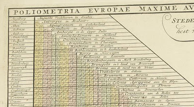
European Distance Chart, Reiner and Josua Ottens, c.1750
OLIOMETRIA EUROPAE MAXIME AUTEM GERMANIAE AC FINITIMORUM LOCURUM EX OFFICINA R. & J. OTTS AMST. An interesting table listing many European towns and cities plus Bethlehem.

Publisher: OTTENS, R. / I.
Title: Poliometria Europae Maxime Autem Germaniae ac Finitimorum Locorum. . .
Published in: Amsterdam, 1720
48.6 x 55.3 cm.

This unusual thematic chart shows the traveling distances from various European cities in a style that is still used in charts today.

Reiner & Josua Ottens: Carte Quirepresente Toutes Les Pieces Qui Sont Comprises Dans L’Architecture Militaire, ou L’Arte Des Fortifications . . .
Description: Scarce map showing approximately 83 smaller illustrations on all aspects of the military sciences, including methods for the construction of fortresses; artillery; sieges of cities; battles; army units, attacks from seaside etc., but Caspar Specht. The text of the legend in Dutch, text in the illustrations in French. Gorgeous old color example.
Title: Carte Quirepresente Toutes Les Pieces Qui Sont Comprises Dans L’Architecture Militaire, ou L’Arte Des Fortifications . . .
Map Maker: Reiner & Josua Ottens
Place / Date: Amsterdam / 1720

Reiner & Josua Ottens: [Wall Map of Spain & Portugal] Novissima et Accuratissima Tabula Qua Gallaeciae et Legionis Regna, Asturiarum … Regnorum Arragoniae et Navarra, Principatus Cataloniae . . .
Title: [Wall Map of Spain & Portugal] Novissima et Accuratissima Tabula Qua Gallaeciae et Legionis Regna, Asturiarum … Regnorum Arragoniae et Navarra, Principatus Cataloniae . . .
Map Maker: Reiner & Josua Ottens
Place / Date: Amsterdam / 1740
Description:
Gorgeous full color example of Luggert van Anse’s 4 sheet map of Spain, Portugal and the Balaeric Islands, joined flawlessly and presented here as a wall map.
Includes a large cartouche with explanations of the political divisions of Spain and Portugal in French and Dutch, headed by coat of arms and 6 compass roses. An uncommon wall map of Spain and Portugal. Luggert van Anse was engraver for Allard, Visscher and van Keulen. This edition was published by Ottens, with additions and corrections. A spectacular example.
Price: $4,800.00

Johannes De Ram / Reiner & Josua Ottens: Regni Angliae Nova Tabula, Exhibens Principatum Walliae, & aliarum Provincia rum Civitatum, Oppidorum, una cum itineribus ab uno in aliam Civitatem
Title: Regni Angliae Nova Tabula, Exhibens Principatum Walliae, & aliarum Provincia rum Civitatum, Oppidorum, una cum itineribus ab uno in aliam Civitatem
Map Maker: Johannes De Ram / Reiner & Josua Ottens
Place / Date: Amsterdam / 1725
Size: 23 x 19.5 inches
Price: $795.00
Description:
Third state of De Ram’s rare map of England, updated and corrected by Reiner & Josua Ottens.
Includes a massive Alphabetical Table of the Cities and Market-Townes on the great roads in England Y Wales, Their Latitude and Longitude and in what County they are Lying . . . Ornate cartouche and rich full color.

Totius Neobelgii nova et accuratissima Tabula
Allard, Hugo (1625 – 1691)/Ottens, Reiner (1698 – 1750) and Ottens, Joshua (1704-1765)
Librería: W. Graham Arader III gallery (New York, NY, U.S.A.)
Descripción:
A MAP OF NEW ENGLAND CONTAINING THE FAMOUS «RESTITUTIO» VIEW Copper-plate engraving with original hand color: plate size 181/2″ x 213/4″ Reference: Philip D. Burden, The Mapping of North America: A List of Printed Maps 1511-1670 (Rickmansworth, 1996), 476-477. This map is one of five that closely follows the Visscher Novii Belgii. It is a magnificent version of Hugo Allard’s edition published by the Ottens brothers, after their purchase of Allard’s plate in 1708, and shows the famous «Restitutio» view of New York. In 1664, the English successfully captured New Amsterdam and renamed it New York. The Dutch were entirely unable to rival the English, but for one brief episode between 1673 and 1674 when they recaptured the city and renamed it New Amsterdam. It was then that this updated version of Visscher’s map was first engraved replacing the inset view of New York with what became dubbed the «Restituto» view. The inset celebrated the ‘restoration’ of New Amsterdam to Holland, in August 1673, by the fleet under the command of Cornelius Evertsen. The figure on the pedestal is holding a laurel of victory, while the updated glimpse at the southern tip of Manhattan shows a city that has grown significantly, and is a triumphant indication of Dutch pride in its recapture. Unlike the Visscher view, here the town is depicted from the east. On the right-hand side of the view is part of the wall that became Wall Street, with its guardhouse and gate. To its right are new settlements that were just beginning to crop up north of the wall. This view actually shows the Dutch capture of the town in progress, with soldiers marching along the quay and a cannon firing from the fort. Despite the fact that the city was returned to the British under the Treaty of Breda the following year, this map with the «Restitutio» view continued to be published for almost a century by Dutch mapmakers, perhaps for reasons of nostalgic national pride. By this time, Dutch overseas power was waning, particularly in America. This view, with its grandiose presentation of momentary triumph, played to the need for some affirmation of Dutch colonial power even in the face of overwhelming evidence to its demise

Schenk Ottens 1700 (1735) – India
MAKER Schenk/Ottens
TITLE Carte des Côtes de Malabar et de Coromandel
PLACE ISSUED Amsterdam
FIRST EDITION 1700
THIS EDITION 1735
SIZE (hxw cms) 44.1 x 57.2
AREA SHOWN India
TECHNIQUE Copper engraving
PAGE NUMBER
SIGNATURE
VERSO blank
COLOURING or.col.
CONDITION The overall quality of this antique map is excellent
DESCRIPTION Reiner and Joshua Ottens’ re-issue of Schenk’s large map of India. Magnificent original colour.
JOACHIM OTTENS
1663-1719
Joachim Ottens and his sons Renier (d.1750) and Joshua (d.1765), were prominent Dutch booksellers and map publishers from about 1680 to 1790. Joachim was initially employed as a copperplate engraver by Frederick de Wit (1630-1706), but founded his own business in 1711. Although he died only a few years later, his sons Renier and Joshua took over the firm and presided over its most prolific period. The Ottens family’s most notable contribution to cartography was its enormous made-to-order multi-volume atlases such as the Atlas Major.

Reiner Ottens. Atlas maior cvm generales omnivm totius orbis regnorvm . . .Amsterdam 1729. Page 2 – Page 3 Hand-colored engraving
REINER OTTENS
(son) 1698-1750
JOSHUA OTTENS
(son) 1704-1765


