MAP GEMS: Familia Ottens, Joachim, Reiner y Joshua

JOACHIM OTTENS (Padre) 1663-1719
REINER AND JOSUA OTTENS (hijos)
(1698-1750 and 1704-1765)
Cartógrafos

The family business of print and map selling was founded by Joachim Ottens but the active period of map publishing was concentrated in the years between 1720 and 1750 when the brothers, Reiner and Joshua, produced enormous collections of maps, some as large as 15 volumes. These, including copies of practically all maps available at the time, were made up to order and were magnificently coloured. Besides these specially prepared collections they also issued single-volume atlases with varying contents as well as pocket atlases.

Cartografía en venta.

Gracias por visitar el sitio de Juantxo Cruz

Publisher: de L’ISLE, G. / OTTENS, R. / I.
Title: Hemisphere meridional pour voir plus distinctement les terres australes. . .
Published in: Amsterdam, 1740

Size: 17.6 x 17.9 inches.
44.7 x 45.4 cm.

Gracias por visitar el sitio de Juantxo Cruz

With the imprint of the Ottens family – rare. An Antarctic map including a recounting of the discovery of an island south of the Cape of Good Hope which was named Cap de la Circoncision in 1739. A small inset map of the discovered island appears in the lower right.
This circular map show the world in an unusual way: using the Poles as the center point of hemispheres that extend to the Equator.
With a text panel in upper left corner : Nouvelles découvertes de 1739 au sud du cap de bonne Esperance par les ordre de M. de la compagnie des Indes. Dressee sur les memoires et sur la carte originale de M. Lozier Bouvet cahrge de cette expédition. Same text in Dutch in upper right corner.
Joachim Ottens (1663 – 1719) and his sons Renier and Joshua were prominent Dutch booksellers and map publishers from about 1680 to 1790. Joachim, the founder of the firm, was initially employed as a copperplate engraver by Frederick de Wit. In 1711 Joachim founded his own firm. Though Joachim died only a few years later, his sons Renier and Joshua took over the firm and presided over its most prolific period.

Gracias por visitar el sitio de Juantxo Cruz

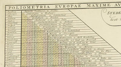
European Distance Chart, Reiner and Josua Ottens, c.1750
OLIOMETRIA EUROPAE MAXIME AUTEM GERMANIAE AC FINITIMORUM LOCURUM EX OFFICINA R. & J. OTTS AMST. An interesting table listing many European towns and cities plus Bethlehem.

Gracias por visitar el sitio de Juantxo Cruz

Publisher: OTTENS, R. / I.
Title: Poliometria Europae Maxime Autem Germaniae ac Finitimorum Locorum. . .
Published in: Amsterdam, 1720
48.6 x 55.3 cm.

Gracias por visitar el sitio de Juantxo Cruz

This unusual thematic chart shows the traveling distances from various European cities in a style that is still used in charts today.

Gracias por visitar el sitio de Juantxo Cruz

Reiner & Josua Ottens: Carte Quirepresente Toutes Les Pieces Qui Sont Comprises Dans L’Architecture Militaire, ou L’Arte Des Fortifications . . .

Description: Scarce map showing approximately 83 smaller illustrations on all aspects of the military sciences, including methods for the construction of fortresses; artillery; sieges of cities; battles; army units, attacks from seaside etc., but Caspar Specht. The text of the legend in Dutch, text in the illustrations in French. Gorgeous old color example.

Title: Carte Quirepresente Toutes Les Pieces Qui Sont Comprises Dans L’Architecture Militaire, ou L’Arte Des Fortifications . . .
Map Maker: Reiner & Josua Ottens
Place / Date: Amsterdam / 1720

Gracias por visitar el sitio de Juantxo Cruz

Reiner & Josua Ottens: [Wall Map of Spain & Portugal] Novissima et Accuratissima Tabula Qua Gallaeciae et Legionis Regna, Asturiarum … Regnorum Arragoniae et Navarra, Principatus Cataloniae . . .

Title: [Wall Map of Spain & Portugal] Novissima et Accuratissima Tabula Qua Gallaeciae et Legionis Regna, Asturiarum … Regnorum Arragoniae et Navarra, Principatus Cataloniae . . .

Map Maker: Reiner & Josua Ottens
Place / Date: Amsterdam / 1740

Description:

Gorgeous full color example of Luggert van Anse’s 4 sheet map of Spain, Portugal and the Balaeric Islands, joined flawlessly and presented here as a wall map.

Includes a large cartouche with explanations of the political divisions of Spain and Portugal in French and Dutch, headed by coat of arms and 6 compass roses. An uncommon wall map of Spain and Portugal. Luggert van Anse was engraver for Allard, Visscher and van Keulen. This edition was published by Ottens, with additions and corrections. A spectacular example.
Price: $4,800.00

Gracias por visitar el sitio de Juantxo Cruz

Johannes De Ram / Reiner & Josua Ottens: Regni Angliae Nova Tabula, Exhibens Principatum Walliae, & aliarum Provincia rum Civitatum, Oppidorum, una cum itineribus ab uno in aliam Civitatem

Title: Regni Angliae Nova Tabula, Exhibens Principatum Walliae, & aliarum Provincia rum Civitatum, Oppidorum, una cum itineribus ab uno in aliam Civitatem

Map Maker: Johannes De Ram / Reiner & Josua Ottens
Place / Date: Amsterdam / 1725
Size: 23 x 19.5 inches
Price: $795.00

Description:
Third state of De Ram’s rare map of England, updated and corrected by Reiner & Josua Ottens.

Includes a massive Alphabetical Table of the Cities and Market-Townes on the great roads in England Y Wales, Their Latitude and Longitude and in what County they are Lying . . . Ornate cartouche and rich full color.

Gracias por visitar el sitio de Juantxo Cruz

Totius Neobelgii nova et accuratissima Tabula
Allard, Hugo (1625 – 1691)/Ottens, Reiner (1698 – 1750) and Ottens, Joshua (1704-1765)
Librería: W. Graham Arader III gallery (New York, NY, U.S.A.)


Descripción:

A MAP OF NEW ENGLAND CONTAINING THE FAMOUS «RESTITUTIO» VIEW Copper-plate engraving with original hand color: plate size 181/2″ x 213/4″ Reference: Philip D. Burden, The Mapping of North America: A List of Printed Maps 1511-1670 (Rickmansworth, 1996), 476-477. This map is one of five that closely follows the Visscher Novii Belgii. It is a magnificent version of Hugo Allard’s edition published by the Ottens brothers, after their purchase of Allard’s plate in 1708, and shows the famous «Restitutio» view of New York. In 1664, the English successfully captured New Amsterdam and renamed it New York. The Dutch were entirely unable to rival the English, but for one brief episode between 1673 and 1674 when they recaptured the city and renamed it New Amsterdam. It was then that this updated version of Visscher’s map was first engraved replacing the inset view of New York with what became dubbed the «Restituto» view. The inset celebrated the ‘restoration’ of New Amsterdam to Holland, in August 1673, by the fleet under the command of Cornelius Evertsen. The figure on the pedestal is holding a laurel of victory, while the updated glimpse at the southern tip of Manhattan shows a city that has grown significantly, and is a triumphant indication of Dutch pride in its recapture. Unlike the Visscher view, here the town is depicted from the east. On the right-hand side of the view is part of the wall that became Wall Street, with its guardhouse and gate. To its right are new settlements that were just beginning to crop up north of the wall. This view actually shows the Dutch capture of the town in progress, with soldiers marching along the quay and a cannon firing from the fort. Despite the fact that the city was returned to the British under the Treaty of Breda the following year, this map with the «Restitutio» view continued to be published for almost a century by Dutch mapmakers, perhaps for reasons of nostalgic national pride. By this time, Dutch overseas power was waning, particularly in America. This view, with its grandiose presentation of momentary triumph, played to the need for some affirmation of Dutch colonial power even in the face of overwhelming evidence to its demise

Gracias por visitar el sitio de Juantxo Cruz

Schenk Ottens 1700 (1735) – India

MAKER Schenk/Ottens
TITLE Carte des Côtes de Malabar et de Coromandel
PLACE ISSUED Amsterdam
FIRST EDITION 1700
THIS EDITION 1735
SIZE (hxw cms) 44.1 x 57.2
AREA SHOWN India
TECHNIQUE Copper engraving
PAGE NUMBER
SIGNATURE
VERSO blank
COLOURING or.col.
CONDITION The overall quality of this antique map is excellent
DESCRIPTION Reiner and Joshua Ottens’ re-issue of Schenk’s large map of India. Magnificent original colour.

JOACHIM OTTENS
1663-1719
Joachim Ottens and his sons Renier (d.1750) and Joshua (d.1765), were prominent Dutch booksellers and map publishers from about 1680 to 1790. Joachim was initially employed as a copperplate engraver by Frederick de Wit (1630-1706), but founded his own business in 1711. Although he died only a few years later, his sons Renier and Joshua took over the firm and presided over its most prolific period. The Ottens family’s most notable contribution to cartography was its enormous made-to-order multi-volume atlases such as the Atlas Major.

Gracias por visitar el sitio de Juantxo Cruz

Reiner Ottens. Atlas maior cvm generales omnivm totius orbis regnorvm . . .Amsterdam 1729. Page 2 – Page 3 Hand-colored engraving

REINER OTTENS
(son) 1698-1750

JOSHUA OTTENS
(son) 1704-1765

GRAPHICS: Best2010, Sagrada Familia

Gracias por visitar el sitio de Juantxo Cruz

La Sagrada Familia
Por Julián de Velasco y Jesús Gil.

Julián nos cuenta:

‘A mediados de marzo, pocos días después de que se anunciara el viaje del Papa a Barcelona para dedicar la Sagrada Familia, Jesús Gil me lanzó el guante: es un temazo, como infografista no puedes dejarlo pasar.
Yo le devolví el guante, acompañándolo con el de la otra mano: ¿hacemos ese gráfico juntos?

Jesús accedió. De hecho, llevó la parte ardua del trabajo: recopilar toda la información posible, analizarla y ordenarla. Lo que consiguió, por cantidad y profundidad del análisis, aseguraba el éxito del gráfico: sería interesante y riguroso.

En esa etapa de búsqueda de fuentes, se dio un hecho insólito: el intercambio de información con el equipo de Fernando Baptista, que estaba realizando un trabajo sobre el mismo tema para National Geographic (lo han publicado en diciembre). Fue una colaboración informal, posible por la amistad entre Fernando y Jesús, y porque nos enviamos material en bruto, sin elaborar. Además, por respeto a la privacidad, en ningún momento nos desvelamos cómo plantearíamos nuestros gráficos, que por otro lado se publicarían en mercados diferentes. Si se comparan las dos infografías, se aprecian puntos en común pero también apuestas informativas diferentes.

Con la documentación masticada, la pelota pasó a mi tejado: me encargaba de la parte gráfica.

En agosto, conseguimos reunirnos un día en Burgos (Jesús vive en Roma y yo en Madrid). Pusimos en claro la estructura de la infografía, que era consecuencia de nuestra síntesis de la Sagrada Familia: unidad entre forma y función, y simbología de cada piedra.

Mientras Jesús pulía una y otra vez los textos hasta llegar a la edición final, yo iba realizando las piezas que encajarían con ellos y a la vez armarían toda la parte visual. Jesús me ayudó a mantener los pies en el suelo, y a que los gráficos e ilustraciones tuvieran el equilibrio justo entre espectáculo e información.

En octubre visité el templo y vi sobre el terreno las obras, el desarrollo del edificio y sus retos. Uno de los arquitectos encargados de los trabajos me acompañó: aclaró dudas y respondió a las preguntas; ésas que, si no es de primera mano, jamás se solucionan, y que uno es capaz de hacerlas cuando antes ya ha estudiado la documentación.

Para los gráficos, nos basamos en fotos del edificio y de las maquetas del propio Gaudí, aparte de algunos planos en alta resolución que nos pasó Fernando. La sección de la nave, que ocupa la parte central del gráfico, fue una pequeña obra de ingeniería para armar la visión general a partir de trozos con perspectivas diferentes.

El gráfico comenzó a crecer entre correos electrónicos de ida y de vuelta, pero llegó un momento en que tuvimos que parar para llegar a tiempo a la fecha de publicación. La cabeza se dispara y los retoques pueden alargarse hasta el infinito, así que darla por terminada fue una pequeña liberación’.

PHOTOS: Louis Jacques Mandé Daguerre, 1787–1851

Gracias por visitar el sitio de Juantxo Cruz

Louis Jacques Mandé Daguerre
1787–1851
Pionero del proceso de la fotografía.

Gracias por visitar el sitio de Juantxo Cruz

Daguerrotipo de la luna
1851
Tomó la primera fotografía de la luna en 1839, pero se perdió todo el material en un incendio.

Gracias por visitar el sitio de Juantxo Cruz

Primera fotografía con personas.
Boulevard du Temple (1838)

Gracias por visitar el sitio de Juantxo Cruz

Daguerrotipo
El daguerrotipo o «daguerreotipo», fue el primer procedimiento fotográfico anunciado y difundido oficialmente en el año 1839. Fue desarrollado y perfeccionado por Louis Daguerre a partir de las experiencias previas inéditas de Joseph-Nicéphore Niépce, y dado a conocer en París, en la Academia de las Ciencias francesa.

GRAPHICS: Informe PISA 2009


Informe PISA

Cada tres años.

Programme for International Student Assessment (PISA) 2009 Results:
What Students Know and Can Do Student Performance in Reading,Mathematics and Science.
OCDE

Gracias por visitar el sitio de Juantxo Cruz

Las clasificaciones en lectura, matemáticas y ciencias.

Methods
• Around 470 000 students completed the assessment in 2009, representing about 26 million 15-year-olds in
the schools of the 65 participating countries and economies. Some 50 000 students took part in a second
round of this assessment in 2010, representing about 2 million 15 year-olds from 9 additional partner
countries and economies.
• Each participating student spent two hours carrying out pencil-and-paper tasks in reading, mathematics and
science. In 20 countries, students were given additional questions via computer to assess their capacity to
read digital texts.
• The assessment included tasks requiring students to construct their own answers as well as multiple-choice
questions. The latter were typically organised in units based on a written passage or graphic, much like the
kind of texts or figures that students might encounter in real life.
• Students also answered a questionnaire that took about 30 minutes to complete. This questionnaire focused
on their personal background, their learning habits, their attitudes towards reading, and their engagement
and motivation.
• School principals completed a questionnaire about their school that included demographic characteristics
and an assessment of the quality of the learning environment at school.

Corrigenda to OECD publications may be found on line at: www.oecd.org/publishing/corrigenda.
PISATM, OECD/PISATM and the PISA logo are trademaks of the Organisation for Economic Co-operation and Development (OECD).
All use of OECD trademarks is prohibited without written permission from the OECD.
© OECD 2010

Angel Gurría
OECD Secretary-General

GRAPHICS: El asesinato de John Lennon

Dirección creativa y de documental del gráfico sobre la muerte de John Lennon.
El 8 de diciembre de 2010 se cumplían 30 años del asesinato del músico de Liverpool a consecuencia de los cinco disparos efectuados por Mark David Chapman en la entrada del edificio donde residía, el Edificio Dakota. Lennon acababa de regresar del estudio de grabación Record Plant Studio con su esposa, Yoko Ono.

Gracias por visitar el sitio de Juantxo Cruz

Boceto rápido, estudio de la perspectiva.

Gracias por visitar el sitio de Juantxo Cruz

Vista isométrica, Juan de Dios Tenorio.

Gracias por visitar el sitio de Juantxo Cruz

Perspectiva cenital, Juan de Dios Tenorio

Gracias por visitar el sitio de Juantxo Cruz

Acabado de la entrada del Dakota, Juan de Dios Tenorio.

Gracias por visitar el sitio de Juantxo Cruz

Primera puesta en página, por Alfonso Everlet.

Gracias por visitar el sitio de Juantxo Cruz

Aclarado de colores.

Gracias por visitar el sitio de Juantxo Cruz

Infografía final.

Gracias por visitar el sitio de Juantxo Cruz

El Mundo, sábado 4 de diciembre

Gracias por visitar el sitio de Juantxo Cruz

Versión internet, por Miguel Nuño.

MAGS: Time Out, Oakley Capital

Gracias por visitar el sitio de Juantxo Cruz

Un fondo de inversión al rescate de una publicación.

TIME OUT
Semanal
Fundado en 1968, Tony Elliot
En enero de 2010 puso sobre la mesa 3 millones de libras para reducir su deuda.
Oakley Capital compra el 50% en noviembre de 2010.
NOTA DE PRENSA

Elliot: «I have considered many potential investors over the last 7 years to help the brand with the next phase of development and I believe that Oakley Capital, with its entrepreneurial operational focus, will help us with this. I genuinely believe that I have found a real partner for what I expect to be a hugely successful worldwide digital journey.»

Frequency: Weekly
Day published: Wednesday
Cover price: £2.99
Annual cover price: £152.49
6 issue trial: £2.99 – save 83%!
Annual credit card subscription: £79.99 – save 48%!
Annual direct debit subscription: £69.99 save 54%!

Gracias por visitar el sitio de Juantxo Cruz

1972

Gracias por visitar el sitio de Juantxo Cruz

1968

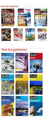
GALERÍA DE PORTADAS.

Time Out Communications Ltd.
Universal House
251 Tottenham Court Road
London
W1T 7AB
Tel: +44 (0)20 7813 3000
Fax: +44 (0)20 7813 6001

The Oakley Group is an asset management and financial advisory business with over $630m of assets under management. It is focused on understanding investors’ interests and requirements, while retaining the flexibility to move quickly and decisively in response to their needs.

Time Out has a worldwide audience of over 17m per annum across all these channels and continues to grow its digital presence, with global unique users per month up 38% year on year to 7.5m, of which over 2m are in London. Time Out also recently launched its location based iPhone applications and has already had over 500,000 downloads in 2010. Time Out publishes a broad range of magazines and guides, its weekly magazine has 36 versions in 24 countries which is complemented by 22 travel magazines and city guides to some 50 cities, translated into 10 languages.

GRAPHICS: 8 de diciembre de 1980, NYC

Gracias por visitar el sitio de Juantxo Cruz

Día del suceso, por la mañana.

Gracias por visitar el sitio de Juantxo Cruz

La muerte de John Lennon
8 de diciembre de 1980, NYC.
Recreación de la policía.

Gracias por visitar el sitio de Juantxo Cruz

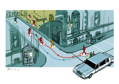
Croquis del asesinato de Lennon.
Astucia Report.
Versión oficial.

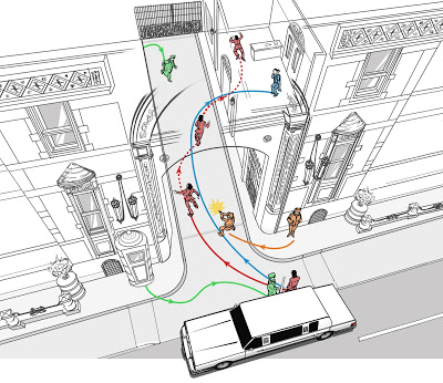
Lennon (1) gets out of limousine. Yoko Ono (4) got out seconds earlier and is about 35 feet ahead. Chapman (2) waits at the entrance under the archway. As Lennon walks by (3), Chapman fires. Ono (5) is in the lobby when Lennon is shot. Lennon staggers about 30 feet to the concierge stand (6) in the lobby where he falls, fatally wounded.

(Note: The dimensions shown in Exhibit B are close approximations based on first-hand observation and painstaking analyses of photographs taken; however, it must be noted that the Dakota’s security people would not allow me to walk inside the entrance and take precise measurements.)

Gracias por visitar el sitio de Juantxo Cruz

Esquema en The New York Times.

(6) A diagram published in the New York Times on Dec. 10, 1980 shows Chapman standing behind Lennon, to his right. The accompanying caption reads as follows:

…Mr. Lennon and Yoko Ono left their car (1), while the assailant (2) waited inside the arch. As they walked by (3), he fired. Mr. Lennon staggered up into a room (4) where he fell, fatally wounded.

Gracias por visitar el sitio de Juantxo Cruz

Mark David Chapman.

Gracias por visitar el sitio de Juantxo Cruz

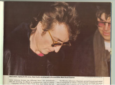
Lennon firmando un autógrafo para Chapman, 12 de agosto de 1980.
Plasticmacca

Lennon signing an autograph for Chapman (12/8/80), whose preoccupation
with Lennon had begun just months before the murder.

Gracias por visitar el sitio de Juantxo Cruz

La entrada al Dakota.
Escena del crimen.

Gracias por visitar el sitio de Juantxo Cruz

Planta del Dakota.

Gracias por visitar el sitio de Juantxo Cruz

El revólver del 38 y los casquillos.

Gracias por visitar el sitio de Juantxo Cruz

Certificado de muerte.

Gracias por visitar el sitio de Juantxo Cruz

Las huellas, registradas cuando pidió la ciudadanía estadounidense en 1976.

Gracias por visitar el sitio de Juantxo Cruz

The FBI files.
The FBI assembled around 300 pages of files on John Lennon in 1971-72, part of President Nixon’s effort to deport Lennon to silence him as a critic of the war in Vietnam.

Gracias por visitar el sitio de Juantxo Cruz

Después el asesinato.

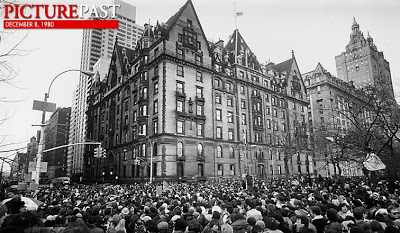
John Lennon was shot dead by Mark Chapman outside the Dakota building, where the former Beatle lived in New York. Crowds gathered outside to pay tribute.

Gracias por visitar el sitio de Juantxo Cruz

La vigilia.
Why?
December 1980: Fans of John Lennon holding a vigil after he was shot dead by a fan on December 8th at his home in New York. (Photo by Hulton Archive/Getty Images)

Gracias por visitar el sitio de Juantxo Cruz

The Green Card
John Lennon’s United States Resident Alien Visa (Green Card) c. 1976. When John Lennon’s temporary visa expired in Feb. 1972, the Nixon administration sought to have him deported, citing a 1968 conviction for the possession of marijuana. After a four-year battle, Lennon finally won the right to stay in the U.S.. In 1983, a lawsuit was brought against the FBI under the Freedom of Information Act to release its files on Lennon, which document the Bureau’s role in the Nixon administration’s attempt to stop Lennon’s anti-war campaign before the 1972 election. Photo:David Behl/©Yoko Ono

Gracias por visitar el sitio de Juantxo Cruz

Nashville Banner.

Gracias por visitar el sitio de Juantxo Cruz

Yoko, LA Times.

Gracias por visitar el sitio de Juantxo Cruz

LA Times.

Gracias por visitar el sitio de Juantxo Cruz

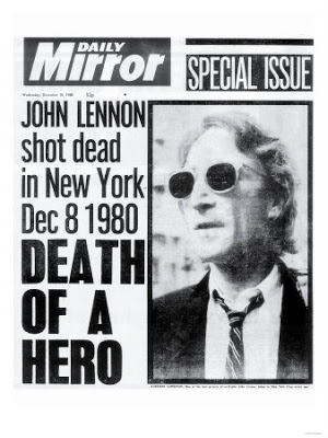
Daily Mirror.

Gracias por visitar el sitio de Juantxo Cruz

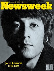
Portada de Newsweek.

Gracias por visitar el sitio de Juantxo Cruz

World Daily News

Gracias por visitar el sitio de Juantxo Cruz

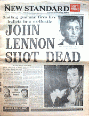
News Standard

Gracias por visitar el sitio de Juantxo Cruz

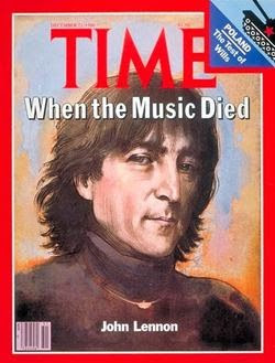
Time.

Gracias por visitar el sitio de Juantxo Cruz

New York Post

Gracias por visitar el sitio de Juantxo Cruz

La conspiración en cómic, MackWhite.

Gracias por visitar el sitio de Juantxo Cruz

Portada del primer Rolling Stone.
9 de noviembre de 1967

Gracias por visitar el sitio de Juantxo Cruz

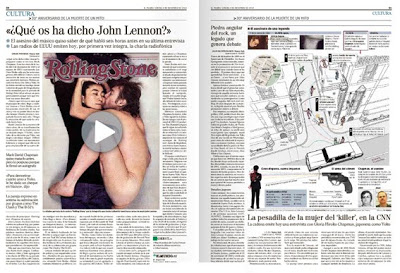
Rolling Stone, enero de 1981

Gracias por visitar el sitio de Juantxo Cruz

Infografía de Beatriz Santacruz en EL MUNDO con motivo del 25 aniversario.
7 de diciembre de 2005

Vídeo de la noticia, ABC News.

La reacción de Reagan.

Reconstrucción del asesinato.

PHOTOS: Las hadas de Cottingley, 1917

Gracias por visitar el sitio de Juantxo Cruz

Las hadas de Cottingley
Serie de cinco fotografías tomadas por las primas Elsie, 16 años, y Frances Griffiths, 10 años, (Bradford, Inglaterra).
1917-18
Las niñas posan junto a varias hadas, probando la existencia de espíritus.
Gran falsificación.
Geoffrey Wakefield Crawley (1916-2010, pionero del análisis fotográfico) demostró que las fotos eran falsas muchos años después ( «Of course there are fairies, just as there is Father Christmas»).
En 1982, Elsie Wright declaró en la BBC que fue un fraude.

!Gracias por visitar mi sitio! | Copyright © 1992- 2025 juantxo_cruz. Todos los derechos reservados.