The Denver Post, 1912

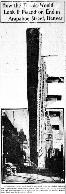
Tenía por alguna carpeta estos gráficos antiguos de The Denver Post sobre el Titanic. Los volvió a publicar, 100 años después de su impresión, Daniel J. Schneider en su blog del diario de Colorado. Daniel explica que este tipo de gráficos «hacen la inmensidad del Titanic más comprensible para el hombre común».
Increíble cobertura y seguimiento informativos.
Aquí los rescato.

Comparación del Titanic con la Torre de Daniels & Fisher de Denver.
Fotocomposición del 16 de abril de 1912.

Comparación de la fuerza de impacto del Titanic con el iceberg con su equivalencia en número de vagones de tren.
17 de abril de 1912.

Diagrama del Titanic.
18 de abril de 1912

Comparación del Titanic con otros barcos.
18 de abril de 1912.

GRAPHIC GEMS: Atlas zu Alex. v. Humboldt’s Kosmos in zweiundvierzig, 1851

Gracias por visitar el sitio de Juantxo Cruz

Atlas zu Alex. v. Humboldt’s Kosmos in zweiundvierzig
Infographic on the composition of the earth’s crust
Stuttgart, Alemania
Verlag von Krais & Hoffmann
1851
42 infografías para la historia.
No sólo un atlas. No sólo mapas.
Incluyen increíbles ilustraciones para explicar los fenómenos naturales.

Gracias por visitar el sitio de Juantxo Cruz

Ver Botanicus

MAS:
Galería en Flickr

Bibliodyssey

The rise of thematic or special purpose cartography, which focuses on mapping the distribution of single or multiple interrelated phenomena, had its origins in the advances in the natural sciences in the late eighteenth and early nineteenth centuries, particularly with the collection of vast amounts of scientific data and the search for innovative techniques of presenting this data graphically. Examples of early physical geography atlases in the Library of Congress include Alexander von Humboldt’s Atlas gographique et physique du royaume de la Nouvelle-Espagne (Paris, 1811), which records his observations during a 1799 to 1804 expedition to South and Central America; Heinrich Berghaus’s three-volume Physikalischer Atlas (Gotha, 1845 1848), the first atlas to portray the physical geography of the world; Alexander Keith Johnston’s Physical Atlas (Edinburgh, 1848), an English adaptation of the Berghaus atlas; and Traugott Broome’s Atlas zu Alex. v. Humboldt’s Kosmos [Stuttgart, 1851 1853], which was prepared to accompany Humboldt’s five-volume Kosmos, a complete physical geography of the universe.

MAPS: Worst1942, Propuesta Europa, Maurice Gomberg

Gracias por visitar el sitio de Juantxo Cruz

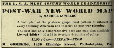
Outline of Post-War New World Map
New World Moral Order
Maurice Gomberg, Philadelphia
Propuesta de EEUU.
Librería del Congreso.
1942
Muy polémico.
Propaganda geoestratégica.
Gracias por visitar el sitio de Juantxo Cruz

The map was self-published by Gomberg and offered for sale for $1 in magazines such as American Teacher in 1942 and Survey Graphic in 1944.

Se puede leer:
Punto 18: ‘The areas known as Netherlands, Belgium, Luxemburg, Switzerland, France, Spain, Portugal, the island of Corsica and eventually Italy and the islands of Sardinia and Sicily shall be unified as a demilitarized, federated «United States of Europe». ‘

About The New World Order Map:

This map was discovered by Helen Somers in a window in Philadelphia during World War II. It was completed in October 1941, before Pearl Harbor, was printed in bright colors by a cartographer named Maurice Gomberg in Philadelphia in 1942, and was displayed in his store window. Helen Somers immediately recognized the significance of the map and purchased several. At least a few original copies are still in existence, including one in the Library of Congress in Washington, DC.

«OUR POLICY SHALL BE THIS:

1. We, the U.S.A., in cooperation with our allies, for reasons of our national safety and in the interests of international morality, are determined to crush and completely destroy the military power of the Axis aggressors, and their satellites regardless of cost, effort and time necessary to accomplish this task.

2. The old world order of colonial oppression, exploitation of dominions, rival imperialism and mercenary balance of power diplomacy; of majesties, dictators, privileged minorities, plutocratic monopolists and similar social parasites; the corrupted order responsible for the present world cataclysm, endangering our national safety and peaceful process, shall never rise again.

3. A New World Moral Order for permanent peace and freedom shall be established at the successful conclusion of the present war.

4. For reasons of history, economic structure, favorable geography and the welfare of mankind, the U.S.A. must, altruistically, assume the leadership of the newly established, democratic world order.

5. To reduce the burden and criminal waste of armaments expenditures everywhere in the world, the U.S.A., with the cooperation of Latin-America, the British Commonwealth of Nations, and the U.S.S.R. shall undertake to guarantee peace to the nations which will be permanently disarmed and demilitarized after the conclusion of the present war.

6. In order to be able, in the fulfillment of our obligations, to effectively prevent the possibility of a recurrence of another world cataclysm, the invincibility of the U.S.A. as a military, naval and air power, shall be the major prerequisite.

7. For realistic considerations of strategy and our invulnerability, it is imperative that the U.S.A. shall obtain relinquishment of controls of their possessions from all foreign Powers in the entire Western Hemisphere, it’s surrounding waters and strategic island outposts as outlined on accompanying map.

8. For considerations of hemispheric defense and in the spirit and tradition of the new Monroe Doctrine of hemispheric solidarity and the «Good Neighbor» policy, the U.S.A. with the consent of the Latin-American Republics, shall obtain control and protectorate rights of the relinquished territories.

9. To strengthen our position in the Caribbean area which is of obvious importance to hemispheric defense, all possible inducements shall be offered to our neighbors of Central America and the West Indies to facilitate their entrance as equal states of the U.S.A. as outlined on map.

10. To fortify the politico-economic unity of the Western Hemisphere, the U.S.A. shall promote and assist the unification of South America into a well organized, democratic, federated «United States of South America.»

11. The liberated British, French and Netherlands Guiana shall be reorganized as one state of the U.S.S.A.

12. All Powers shall relinquish their controls of their colonial, mandate and strategic island possessions everywhere in the world.

13. The British Commonwealth of Nations, the second military and naval Power of importance cooperating in a binding compact with the U.S.A. as a Power for freedom, shall retain and acquire control such territories, peace-security bases and strategic islands outposts essential for the maintenance of world peace and freedom as outlines on the map.

14. The U.S.S.R., the third military Power of importance cooperating with the U.S.A. as a Power for freedom and the maintenance of world peace, shall acquire control of the liberated, disorganized adjacent areas and those of Germany-Austria to be re-educated and eventually incorporated as equal republics of the U.S.S.R., as approximately outlined on map.

15. A world League of Nationalities with arbitration and supervision powers shall be organized.

16. A World Court with punitive powers of absolute boycott, quarantine, blockade and occupation by international police, against lawbreakers of international morality shall be organized.

17. The U.S.A. with the close cooperation of the United States of South America, the British Commonwealth of Nations, the U.S.S.R. and the World League of Nationalities, shall promote and assist in the unification of the relinquished territories and the areas at present unsoundly divided into well organized democratic and absolutely demilitarized republics as approximately on the map.

18. The areas known as Netherlands, Belgium, Luxemburg, Switzerland, France, Spain, Portugal, the island of Corsica, and eventually Italy and the islands of Sardinia and Sicily shall be unified as a demilitarized, federated «United States of Europe.»

19. The areas known as Sweden, Norway, Denmark and the Spitsbergen islands shall be unified as a demilitarized, federated «United States of Scandinavia.»

20. The continent of Africa shall be reorganized and unified as a demilitarized, federated «Union of African Republics.»

21. The areas of Saudi Arabia, Syria, Lebanon, Iraq, Hejas, Aden and Oman, shall be unified as a demilitarized union of «Arabian Federated Republics.»

22. The areas known as India, including Afghanistan, Baluchistan, Nepal, Bhutan and Burma shall be unified as a demilitarized «federated Republics of India.»

23. The areas known as China, Inner Mongolia, Tibet, Thailand, Malaya, Indo-China and Korea, shall be unified as a demilitarized, federated «United Republics of China.»

24. The areas known as Greece, Macedonia, Albania, Crete, Dodecanese and adjacent islands in the Aegean sea shall be unified as a demilitarized «Federal Republic of Greece.»

25. The areas known as Eire and Northern Ireland shall be unified as a demilitarized independent republic of «Eire.»

26. The area of the Holy Land of the ancient Hebrews, at present known as Palestine and Trans-Jordan, and the adjacent requisite regions as outlined on map, for considerations of history and the imperative necessity to alleviate a post war refugee problem, shall be unified as a demilitarized republic of «Hebrewland.»

27. The area known as European Turkey, adjacent to the Dardanelles, sea of Marmora and Bosporus, for considerations of realistic peace strategy shall be placed under joint control of the U.S.S.R. and Turkey.

28. The area known as Turkey shall be a demilitarized independent republic of «Turkey.»

29. All problems of exchange, transfer and repatriation of populations shall be administered by the World League of Nationalities.

30. The criminal perpetrators and their partners in guilt of this hideous war shall be brought to justice and unforgettable punishment administered.

31. All subjects of Japan and all persons of Japanese origin of doubtful loyalty shall be expelled from the entire Western Hemisphere, U.S.A. protectorates and strategic island outposts and their property confiscated for post-war reconstruction needs.

32. All subjects of Germany and Italy and all persons of German and Italian origin known as active supporters of Nazi and fascist ideologies shall be treated similarly.

33. German, Italian, Japanese immigration to the Western Hemisphere, its protectorates and island outposts shall be indefinitely stopped.

34. All persons of German origin in East Prussia and the Rhineland shall be transferred to inner Germany and the regions permanently de-Prussianized.

35. All persons of German, Italian and Japanese origin shall be permanently expelled from their now conquered territories and their property confiscated for post-war construction needs.

36. To cleanse the populations of the defeated Axis aggressors of the intoxication of military chauvinism; to effectuate the removal and destruction of their potential military establishments; to recover the accumulated loot and to re-educate them for their eventual membership in the Family of Nations, the areas of Germany-Austria, Italy and Japan shall be hermetically and indefinitely quarantined and administered by appointed Governors subject to supervision by the world League of Nationalities.

37. All resources, industrial and labor capacity of quarantined areas shall be employed for the post war restoration and reconstruction needs.

38. To reduce the numerical power of the aggressor nations, as a potential military advantage, a Population Control Policy shall be elaborated and applied in the quarantined area.

39. In the New World Moral Order which we seek to establish, besides the essential political freedoms, the following fundamental economic changes are imperative:

(a) Nationalization of all natural resources and equitable distribution of same to all nations…everywhere in the world;

(b) Nationalization of international banking, foreign investments, railroads and power plants….everywhere in the world;

(c) Nationalization of all armaments producing establishments by all military powers;

(d) Federal control of foreign commerce and shipping;

(e) The establishment of a world common monetary system;

(f) World wide limitations of interest rates to a maximum of two percent;

40. To retain the victory and leadership of our united democratic effort….the aim of which is not vengeance or exploitation, but freedom and security to all nations for peaceful progress….the unified «Supreme War Command of the United Nations» at the conclusion of the present war, shall be recognized and transformed into a permanent «Supreme Military and Economic Council» collaborating with the World League of Nationalities in post war construction and to enforce world peace.

41. The «Supreme Military and Economic Council» shall appoint the Governors to administer the quarantined areas until their eventual parole.

For this purposeful beginning we must fight until absolute victory.»

Gracias por visitar el sitio de Juantxo Cruz

Compare the 1942 Map to the US Commands, which reflect America’s deployment of military might and wars of conquest (Editor of Global Research)

Gracias por visitar el sitio de Juantxo Cruz

Irish Times encantado.
Proponía una Irlanda unida
‘The areas known as Eire and Northern Ireland shall be unified as a demilitarized independent republic of «Eire.»

Gracias por visitar el sitio de Juantxo Cruz

También un Estado hebreo.
Smaller entities include Eire (the whole of Ireland), Greece (including Albania), Turkey (excluding European Turkey), Hebrewland (the Holy Land plus Jordan) and Japan. The three axis states (Germany, Italy and Japan) were to be ‘quarantained’ until they could be readmitted in the family of nations.

Gracias por visitar el sitio de Juantxo Cruz

El mundo real en 1945
ONU.

DESIGN GEMS: Chuck Jordan, 1927-2010

Gracias por visitar el sitio de Juantxo Cruz

Charles ‘Chuck’ Jordan
Un estilista de leyenda.
Genial.
Mágico.
50 años en General Motors.
Desde 1986, vicepresidente de Diseño de General Motors.
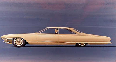
Diseñó el Pontiac, Firebird III, Chevrolet Biscayne, Corvette, Cadillacs, …
Coches de ensueño.
GALERÍA.

Gracias por visitar el sitio de Juantxo Cruz

The 1956 Buick Centurion was the first car designed by Chuck Jordan, who would later become G.M.’s styling chief
Galería en NYT.

Gracias por visitar el sitio de Juantxo Cruz

Prototipos de Jordan.

Gracias por visitar el sitio de Juantxo Cruz

Prototipos de Jordan.

Gracias por visitar el sitio de Juantxo Cruz

MAP GEMS: J. Kellick Bathurst, History Of The Civil War, 1860-1865

J. Kellick Bathurst

Gracias por visitar el sitio de Juantxo Cruz

Library of Congress Geography and Map Division
History of the Civil War in the United States, 1860-1865 J. Kellick Bathurst, compiler; Edward Perrin, del.; Courier Litho. Co., Buffalo, N.Y. (Civil War Map Poster measured in inches 26 x 36)
Amazon

Gracias por visitar el sitio de Juantxo Cruz

This time line map of the United States Civil War was originally produced in the mid 1860’s, by Comparative Synoptical Chart Co, Ltd.
Dimensions: 26″ x 36″
Item #1W-US-CW-1860
Shipping Weight: 2 lbs.
PRICE: $44.95

Mapas históricos de EEUU
1600-1938

El Rev. Green da acceso a una visualización óptima del gráfico.
Aquí.

POSTER GEMS: Golden Age of Travel, 1920-1940

Boston Public Library
Mapas de viajes
Vistos en Cartogrammar
Flickr

CARTOGRAMAR
Who: Andy Woodruff, cartographer.
What: Maps! Cartography!
Where: Cambridge, Massachusetts.
Elsewhere: Twitter inanity. Delicious bookmarks. Flickr photos (more here too).
contact: awoodruff@gmail.com.

Gracias por visitar el sitio de Juantxo Cruz

The gentle art of civilized living
File name: 08_05_000036
Title: The gentle art of civilized living
Creator/Contributor: Treidler, Adolph, b. 1886 (artist)
Date issued: 1934
Physical description: 1 print (poster) : color
Genre: Travel posters; Prints
Subjects: Bars; Ocean travel; Compagnie générale transatlantique
Notes: Title from item.
Statement of responsibility: Adolph Treidler
Location: Boston Public Library, Print Department
Rights: Rights status not evaluated

Gracias por visitar el sitio de Juantxo Cruz

Visitez Belle-Ile-en-Mer. En pleine mer en Bretagne
File name: 08_05_000023

Title: Visitez Belle-Ile-en-Mer. En pleine mer en Bretagne
Created/Published: France : Lucien Serre & Cie. Imp.
Date issued: 1910-1959 (approximate)
Physical description: 1 print (poster) : color
Genre: Travel posters; Prints
Subjects: Tourism
Notes: Title from item.; Printed in France
Statement of responsibility: P. Cadre
Location: Boston Public Library, Print Department
Rights: Rights status not evaluated

Gracias por visitar el sitio de Juantxo Cruz

Doppeldeckzuge
File name: 08_05_000141

Title: Doppeldeckzuge. Hamburg Lübeck travemünde. Aus dem Häusermeer an die see
Creator/Contributor: Templeton, Peter S. (Peter Smith), 1875-1971 (artist)
Date issued: 1910-1959 (approximate)
Physical description: 1 print (poster) : color
Genre: Travel posters; Prints
Subjects: Railroad travel; Railroads; Lübeck-Büchener Eisenbahn-Gesellschaft
Notes: Title from item.
Statement of responsibility: Peter S. Templeton
Location: Boston Public Library, Print Department
Rights: Rights status not evaluated

Gracias por visitar el sitio de Juantxo Cruz

Jura Suisse. Ligne lectrifie du Jura Suisse voitures directes
File name: 08_05_000239
Title: Jura Suisse. Ligne électrifiée du Jura Suisse voitures directes
Created/Published: Neuchatel [Switzerland] : Paul Attinger S. A.
Date issued: 1910-1959 (approximate)
Physical description: 1 print (poster) : color
Genre: Travel posters; Prints
Subjects: Railroads
Notes: Title from item.
Statement of responsibility: Coulon
Location: Boston Public Library, Print Department
Rights: Rights status not evaluated

Gracias por visitar el sitio de Juantxo Cruz

See Boulder Dam enroute to California
File name: 08_05_000298
Title: See Boulder Dam enroute to California
Created/Published: Chicago
Date issued: 1935 (inferred)
Physical description: 1 print (poster) : lithograph, color
Genre: Travel posters; Lithographs
Subjects: Dams; Union Pacific Railroad Company
Notes: Title from item.; Litho in U.S.A.; Caption on image: Actual photograph of World’s Largest Dam taken at Dedication Ceremonies, Sept. 30. 1935. Reached only via North Western-Union Pacific — the Boulder Dam route
Location: Boston Public Library, Print Department
Rights: Rights status not evaluated

Gracias por visitar el sitio de Juantxo Cruz

Proclamation by the King of the Carnival
File name: 08_05_000309
Title: Proclamation by the King of the Carnival
Date issued: 1936 (inferred)
Physical description: 1 print (poster) : color
Genre: Travel posters; Prints
Subjects: Kings; Celebrations; Tourism
Notes: Title from item.; Caption below title: Greeting … the King will pay his annual visit to His beloved capital city of New Orleans on the great fête day of Mardi Gras; Bad tear along bottom.
Location: Boston Public Library, Print Department
Rights: Rights status not evaluated

The Boston Public Library’s Print Department is home to more than 350 vintage travel posters, most dating from the 1920s-1940s, the «Golden Age of Travel.»

Railways opened up America and Europe, luxe ocean liners introduced elegance into
overseas voyages, and drivers took to the road in record numbers in their new automobiles. By the mid-1940s, new airlines crisscrossed the globe, winging adventure-seekers to far-flung destinations.

Travel agents and ticket offices during this period were festooned with vivid, eye-catching posters, all designed to capture the beauty, excitement and adventure of travel and to promote a world of enticing destinations and new modes of transportation. Individual artists gained fame for their distinctive graphic styles and iconic imagery, and many posters from this era still remain important works of art long after their original advertising purposes have faded.

MAP GEMS: Familia Ottens, Joachim, Reiner y Joshua

JOACHIM OTTENS (Padre) 1663-1719
REINER AND JOSUA OTTENS (hijos)
(1698-1750 and 1704-1765)
Cartógrafos

The family business of print and map selling was founded by Joachim Ottens but the active period of map publishing was concentrated in the years between 1720 and 1750 when the brothers, Reiner and Joshua, produced enormous collections of maps, some as large as 15 volumes. These, including copies of practically all maps available at the time, were made up to order and were magnificently coloured. Besides these specially prepared collections they also issued single-volume atlases with varying contents as well as pocket atlases.

Cartografía en venta.

Gracias por visitar el sitio de Juantxo Cruz

Publisher: de L’ISLE, G. / OTTENS, R. / I.
Title: Hemisphere meridional pour voir plus distinctement les terres australes. . .
Published in: Amsterdam, 1740

Size: 17.6 x 17.9 inches.
44.7 x 45.4 cm.

Gracias por visitar el sitio de Juantxo Cruz

With the imprint of the Ottens family – rare. An Antarctic map including a recounting of the discovery of an island south of the Cape of Good Hope which was named Cap de la Circoncision in 1739. A small inset map of the discovered island appears in the lower right.
This circular map show the world in an unusual way: using the Poles as the center point of hemispheres that extend to the Equator.
With a text panel in upper left corner : Nouvelles découvertes de 1739 au sud du cap de bonne Esperance par les ordre de M. de la compagnie des Indes. Dressee sur les memoires et sur la carte originale de M. Lozier Bouvet cahrge de cette expédition. Same text in Dutch in upper right corner.
Joachim Ottens (1663 – 1719) and his sons Renier and Joshua were prominent Dutch booksellers and map publishers from about 1680 to 1790. Joachim, the founder of the firm, was initially employed as a copperplate engraver by Frederick de Wit. In 1711 Joachim founded his own firm. Though Joachim died only a few years later, his sons Renier and Joshua took over the firm and presided over its most prolific period.

Gracias por visitar el sitio de Juantxo Cruz

European Distance Chart, Reiner and Josua Ottens, c.1750
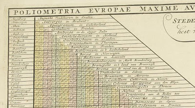
OLIOMETRIA EUROPAE MAXIME AUTEM GERMANIAE AC FINITIMORUM LOCURUM EX OFFICINA R. & J. OTTS AMST. An interesting table listing many European towns and cities plus Bethlehem.

Gracias por visitar el sitio de Juantxo Cruz

Publisher: OTTENS, R. / I.
Title: Poliometria Europae Maxime Autem Germaniae ac Finitimorum Locorum. . .
Published in: Amsterdam, 1720
48.6 x 55.3 cm.

Gracias por visitar el sitio de Juantxo Cruz

This unusual thematic chart shows the traveling distances from various European cities in a style that is still used in charts today.

Gracias por visitar el sitio de Juantxo Cruz

Reiner & Josua Ottens: Carte Quirepresente Toutes Les Pieces Qui Sont Comprises Dans L’Architecture Militaire, ou L’Arte Des Fortifications . . .

Description: Scarce map showing approximately 83 smaller illustrations on all aspects of the military sciences, including methods for the construction of fortresses; artillery; sieges of cities; battles; army units, attacks from seaside etc., but Caspar Specht. The text of the legend in Dutch, text in the illustrations in French. Gorgeous old color example.

Title: Carte Quirepresente Toutes Les Pieces Qui Sont Comprises Dans L’Architecture Militaire, ou L’Arte Des Fortifications . . .
Map Maker: Reiner & Josua Ottens
Place / Date: Amsterdam / 1720

Gracias por visitar el sitio de Juantxo Cruz

Reiner & Josua Ottens: [Wall Map of Spain & Portugal] Novissima et Accuratissima Tabula Qua Gallaeciae et Legionis Regna, Asturiarum … Regnorum Arragoniae et Navarra, Principatus Cataloniae . . .

Title: [Wall Map of Spain & Portugal] Novissima et Accuratissima Tabula Qua Gallaeciae et Legionis Regna, Asturiarum … Regnorum Arragoniae et Navarra, Principatus Cataloniae . . .

Map Maker: Reiner & Josua Ottens
Place / Date: Amsterdam / 1740

Description:

Gorgeous full color example of Luggert van Anse’s 4 sheet map of Spain, Portugal and the Balaeric Islands, joined flawlessly and presented here as a wall map.

Includes a large cartouche with explanations of the political divisions of Spain and Portugal in French and Dutch, headed by coat of arms and 6 compass roses. An uncommon wall map of Spain and Portugal. Luggert van Anse was engraver for Allard, Visscher and van Keulen. This edition was published by Ottens, with additions and corrections. A spectacular example.
Price: $4,800.00

Gracias por visitar el sitio de Juantxo Cruz

Johannes De Ram / Reiner & Josua Ottens: Regni Angliae Nova Tabula, Exhibens Principatum Walliae, & aliarum Provincia rum Civitatum, Oppidorum, una cum itineribus ab uno in aliam Civitatem

Title: Regni Angliae Nova Tabula, Exhibens Principatum Walliae, & aliarum Provincia rum Civitatum, Oppidorum, una cum itineribus ab uno in aliam Civitatem

Map Maker: Johannes De Ram / Reiner & Josua Ottens
Place / Date: Amsterdam / 1725
Size: 23 x 19.5 inches
Price: $795.00

Description:
Third state of De Ram’s rare map of England, updated and corrected by Reiner & Josua Ottens.

Includes a massive Alphabetical Table of the Cities and Market-Townes on the great roads in England Y Wales, Their Latitude and Longitude and in what County they are Lying . . . Ornate cartouche and rich full color.

Gracias por visitar el sitio de Juantxo Cruz

Totius Neobelgii nova et accuratissima Tabula
Allard, Hugo (1625 – 1691)/Ottens, Reiner (1698 – 1750) and Ottens, Joshua (1704-1765)
Librería: W. Graham Arader III gallery (New York, NY, U.S.A.)


Descripción:

A MAP OF NEW ENGLAND CONTAINING THE FAMOUS «RESTITUTIO» VIEW Copper-plate engraving with original hand color: plate size 181/2″ x 213/4″ Reference: Philip D. Burden, The Mapping of North America: A List of Printed Maps 1511-1670 (Rickmansworth, 1996), 476-477. This map is one of five that closely follows the Visscher Novii Belgii. It is a magnificent version of Hugo Allard’s edition published by the Ottens brothers, after their purchase of Allard’s plate in 1708, and shows the famous «Restitutio» view of New York. In 1664, the English successfully captured New Amsterdam and renamed it New York. The Dutch were entirely unable to rival the English, but for one brief episode between 1673 and 1674 when they recaptured the city and renamed it New Amsterdam. It was then that this updated version of Visscher’s map was first engraved replacing the inset view of New York with what became dubbed the «Restituto» view. The inset celebrated the ‘restoration’ of New Amsterdam to Holland, in August 1673, by the fleet under the command of Cornelius Evertsen. The figure on the pedestal is holding a laurel of victory, while the updated glimpse at the southern tip of Manhattan shows a city that has grown significantly, and is a triumphant indication of Dutch pride in its recapture. Unlike the Visscher view, here the town is depicted from the east. On the right-hand side of the view is part of the wall that became Wall Street, with its guardhouse and gate. To its right are new settlements that were just beginning to crop up north of the wall. This view actually shows the Dutch capture of the town in progress, with soldiers marching along the quay and a cannon firing from the fort. Despite the fact that the city was returned to the British under the Treaty of Breda the following year, this map with the «Restitutio» view continued to be published for almost a century by Dutch mapmakers, perhaps for reasons of nostalgic national pride. By this time, Dutch overseas power was waning, particularly in America. This view, with its grandiose presentation of momentary triumph, played to the need for some affirmation of Dutch colonial power even in the face of overwhelming evidence to its demise

Gracias por visitar el sitio de Juantxo Cruz

Schenk Ottens 1700 (1735) – India

MAKER Schenk/Ottens
TITLE Carte des Côtes de Malabar et de Coromandel
PLACE ISSUED Amsterdam
FIRST EDITION 1700
THIS EDITION 1735
SIZE (hxw cms) 44.1 x 57.2
AREA SHOWN India
TECHNIQUE Copper engraving
PAGE NUMBER
SIGNATURE
VERSO blank
COLOURING or.col.
CONDITION The overall quality of this antique map is excellent
DESCRIPTION Reiner and Joshua Ottens’ re-issue of Schenk’s large map of India. Magnificent original colour.

JOACHIM OTTENS
1663-1719
Joachim Ottens and his sons Renier (d.1750) and Joshua (d.1765), were prominent Dutch booksellers and map publishers from about 1680 to 1790. Joachim was initially employed as a copperplate engraver by Frederick de Wit (1630-1706), but founded his own business in 1711. Although he died only a few years later, his sons Renier and Joshua took over the firm and presided over its most prolific period. The Ottens family’s most notable contribution to cartography was its enormous made-to-order multi-volume atlases such as the Atlas Major.

Gracias por visitar el sitio de Juantxo Cruz

Reiner Ottens. Atlas maior cvm generales omnivm totius orbis regnorvm . . .Amsterdam 1729. Page 2 – Page 3 Hand-colored engraving

REINER OTTENS
(son) 1698-1750

JOSHUA OTTENS
(son) 1704-1765

BOOK GEMS: From Hieroglyphics To Isotye, Neurath

Gracias por visitar el sitio de Juantxo Cruz

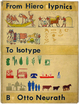
From Hieroglyphics To Isotye
Otto Neurath
1944
AQUI EN AMAZON.
35$

Fantástico enlace dónde se pueden ver los trabajos de Otto Neurath, Marie Neurath (Reidemeister), Ivan Ivanitskii y Gerd Arntz.

Gracias por visitar el sitio de Juantxo Cruz

Gesellschaft und Wirtschaft
Leipzig: Bibliographisches Institut, 1930, 300 x 450 mm, (I.C. 7.1 Ges)
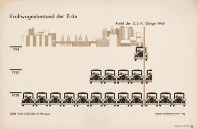
Gesellschaft und Wirtschaft was a monumental collection of one hundred statistical charts printed on loose leaves. Due to a generous commission from the publisher, money was no object and the Vienna team expanded by hiring outside consultants for this publication.
The chart above (no.56) is titled ‘Numbers of motor vehicles in the world’ (USA and rest of the world). Even if one cannot read German, the subject reveals itself through the ‘speaking signs’ of the automobiles, each of which represents 2.5 million vehicles. The grey/brown ‘guide-picture’ (as Neurath called it) at the top of the chart gives further context ‘outside the root picture’, in this case indicating the greater industrial development of automobile production in the USA.

Gracias por visitar el sitio de Juantxo Cruz

‘Tips for tots’
cover design for book, Otto and Marie Neurath, 1944.

Tips for tots’ was a handcrafted mock-up made by the Neuraths as part of a proposal for a series of children’s books sent to Max Parrish in 1944. The mock-up was accompanied by a paper written by Otto Neurath, ‘Isotype books for children’. In it he compares Isotype charts with photographs: charts, he said, are a way of encouraging reasoning based on visual statements, while photographs are a way of making children familiar with the appearance of landscapes, animals, plants.
‘Tips for tots’ introduces Iso and Typie, two characters who had adventures in an Isotype world. This world was designed to bring Iso and Typie into contact with complex phenomena of a kind that would benefit from explanation according to Isotype principles: map-making, tornadoes, radio transmission. By ‘Isotype world’, Neurath meant an Isotype vocabulary: consistent symbolic forms for people, animals, houses, a restricted colour scheme and a particular way of organizing these elements. (SW)
area of research: Isotype childrens’ books (Walker)

Gracias por visitar el sitio de Juantxo Cruz

Voter registration in the Western Region of Nigeria
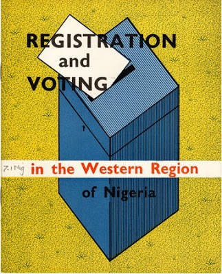
booklet cover, Marie Neurath / Isotype Institute, 1955, 205 x 165 mm, (I.C. 7.1, ‘N’)
Some of the most significant work done by the Isotype Institute as consultants to the Western Region of Nigeria involved the registration of voters, and instructions on how and where to vote. In addition to booklets produced for successive election cycles in 1956 and 1957 (above, for 1956), Isotype designed accompanying posters that encouraged participation, and identified registration offices and polling stations (below, in Yoruba: 510 × 760 mm).

Gracias por visitar el sitio de Juantxo Cruz

Isotype ‘Picture dictionary’
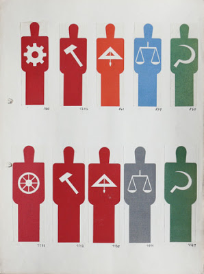
leaf from binder, Gerd Arntz, 1929-33, 300 x 225 mm, (I.C. 4/2)
The Isotype ‘Picture dictionary’ was a working reference file of all pictograms designed by Gerd Arntz. It was begun in Vienna and continually updated. Above is one of the sheets in the category ‘Man’, dating from the early period at the Gesellschafts- und Wirtschaftsmuseum in Vienna. It shows the grammatical aspect of Isotype pictogram design, in which a symbol can be qualified, or made into a kind of compound noun, by combining it with another. The symbols within the human figures here indicate different kinds of profession.

Gracias por visitar el sitio de Juantxo Cruz

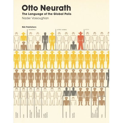
The Language of the Global Polis
Otto Neurath
Amazon.
35$

Hardcover: 176 pages
Publisher: NAi Publishers (July 1, 2008)
Language: English
ISBN-10: 9056623508
ISBN-13: 978-9056623500
Product Dimensions: 10.1 x 7.9 x 0.8 inches

Austrian sociologist Otto Neurath was a seminal Modernist figure. Much attention has been given to his achievements in the fields of graphic design and philosophy (Neurath was a member of the Vienna Circle, founder of the Museum of Society and Economy, inventor of the ISOTYPE pictorial system and champion of the Unity of Science movement), yet his involvement with urbanism and architecture has been all but ignored. From 1931 onwards, Neurath collaborated with the International Congress of Modern Architecture and its chief exponents–Cornelis van Eesteren, Sigfried Giedion, Le Corbusier and Laszlo Moholy-Nagy–to develop an international language of urban planning and design. More experimentally, throughout the 1930s a fascination with visual media led to an attempt to franchise the Museum of Society and Economy by establishing international satellite museums. This volume contains a text by curator and writer Nader Vossoughian, which offers a fresh perspective on one of the most versatile intellectuals of the twentieth century.

Gracias por visitar el sitio de Juantxo Cruz

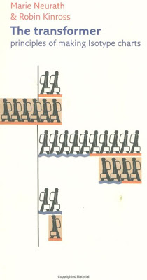
The Transformer: Principles of Making Isotype Charts [Paperback]
Marie Neurath (Author), Robin Kinross (Editor)
Amazon.
20$

Paperback: 126 pages
Publisher: Hyphen Press; 1 edition (September 16, 2009)
Language: English
ISBN-10: 0907259405
ISBN-13: 978-0907259404
Product Dimensions: 8.2 x 4.9 x 0.3 inches

Isotype (International System of Typographic Picture Education) is a system of pictograms designed to communicate complex information in a nonverbal way. Developed in 1936 by a team of sociologists lead by Otto and Marie Neurath, this process of «transforming» data into visual form has strongly influenced the fields of graphic design. The Transformer: Principles of Making Isotype Charts is the first English-language primer on Isotype the foundation of the modern-day pictographic signals found in airports, train stations, highway signs, and computer interfaces. Featuring illustrated examples and essays, including a previously unpublished essay by Marie Neurath, The Transformer is a long-overdue appreciation of an important moment in the history of visual communication.

Gracias por visitar el sitio de Juantxo Cruz

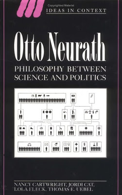
Otto Neurath: Philosophy between Science and Politics (Ideas in Context) [Paperback]
Nancy Cartwright (Author), Jordi Cat (Author), Lola Fleck (Author), Thomas E. Uebel (Author)

Amazon.
58-100$

Paperback: 308 pages
Publisher: Cambridge University Press; 1 edition (May 12, 2008)
Language: English
ISBN-10: 0521041112
ISBN-13: 978-0521041119
Product Dimensions: 8.8 x 6 x 0.6 inches

GRAPHIC GEMS: Los Angeles, foto diagramas ’30s

Curiosos ‘foto diagramas’ de los años 30-40 en Los Ángeles.

Gracias por visitar el sitio de Juantxo Cruz

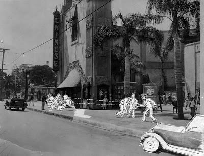
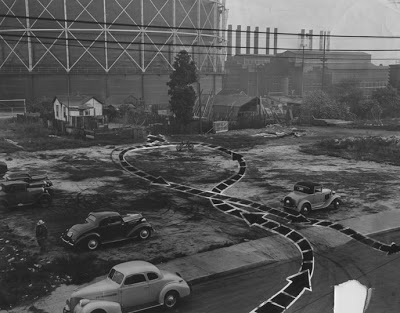
Photograph caption reads, «Photo-diagram of yesterday’s holdup at Grauman’s Chinese Theater, in which robbers escaped with two days’ receipts of $15,000. Officer Crowley is shown firing at the trio, who return the fusillade, wounding James P. Thorpe, a bystander.» Photograph dated July 16, 1929.

Gracias por visitar el sitio de Juantxo Cruz

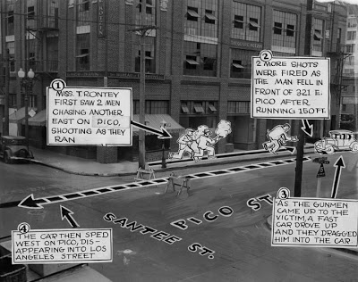
Lena Trontey shows how she looked through a window of her apartment and saw a man «put on the spot» by gunmen. The photo-diagram shows the scene of the shooting as viewed from Miss Trontey’s window and what she saw, according to her story, included the gunmen taking their victim with them. This crime took place outside Theodore Kotzin, located on East Pico. Photo dated: August 11, 1930.

Gracias por visitar el sitio de Juantxo Cruz

This photo-diagram shows where a beautiful blonde girl was found stabbed to death at 721 Turner Street, downtown, east of Alameda, in the industrial area, south of where the 101 freeway would be now, adjacent to the Arts District. Dotted lines shows the path of the car of her slayer. Cross shows where her nude body was found. Marks on the ground indicated that she had put up a terrific struggle for life. Photo dated: December 26, 1939.

Gracias por visitar el sitio de Juantxo Cruz

1949, body in the LA River

Encontrado aquí gracias a Rafa.

Viene de LOS ANGELES PUBLIC LIBRARY

PHOTOS: Louis Jacques Mandé Daguerre, 1787–1851

Gracias por visitar el sitio de Juantxo Cruz

Louis Jacques Mandé Daguerre
1787–1851
Pionero del proceso de la fotografía.

Gracias por visitar el sitio de Juantxo Cruz

Daguerrotipo de la luna
1851
Tomó la primera fotografía de la luna en 1839, pero se perdió todo el material en un incendio.

Gracias por visitar el sitio de Juantxo Cruz

Primera fotografía con personas.
Boulevard du Temple (1838)

Gracias por visitar el sitio de Juantxo Cruz

Daguerrotipo
El daguerrotipo o «daguerreotipo», fue el primer procedimiento fotográfico anunciado y difundido oficialmente en el año 1839. Fue desarrollado y perfeccionado por Louis Daguerre a partir de las experiencias previas inéditas de Joseph-Nicéphore Niépce, y dado a conocer en París, en la Academia de las Ciencias francesa.

!Gracias por visitar mi sitio! | Copyright © 1992- 2024 juantxo_cruz. Todos los derechos reservados.