

 Estudio del terremoto y su réplicas.
NASA
Estudio del terremoto y su réplicas.
NASA.

Topografía.
NASA.
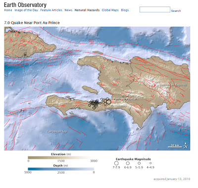
At 4:53 p.m. local time on January 12, 2010, a 7.0-magnitude earthquake struck Hispaniola Island, just 15 kilometers (10 miles) southwest of the Haitian capital of Port-au-Prince. Besides its strong magnitude, the earthquake’s shallow depth of roughly 8.3 kilometers (5.2 miles) ensured that the densely populated capital suffered violent shaking.
This map shows the topography and tectonic influences in the region of the earthquake. Ocean areas appear in shades of blue, and land areas appear in shades of brown. Lighter colors indicate higher elevation on land and shallower depth in the water. Black circles mark earthquake locations determined by the USGS, and circle sizes correspond with quake magnitudes. Dozens of aftershocks followed the main quake. Red lines indicate fault lines.
The USGS reported that the earthquakes occurred along the boundary between the Caribbean and North America plates. The two tectonic plates meet at a strike-slip fault, with the Caribbean plate moving eastward with respect to the North America plate. The January 12 earthquake was the worst to strike the region in decades, and possibly well over a century.
According to news reports, schools, hospitals, government buildings,